Fresh lakes of the Kuban. Lakes of the Krasnodar Territory Lakes of the Kuban Steppe estuaries etc. Mountain lakes named after scientific travelers
home
Lakes and estuaries Lakes in Krasnodar region , compared to other regions of our country, is relatively small. In the territory Krasnodar region
, covering the flat territories of the Western Ciscaucasia and the mountains of the Western Caucasus, including on the Black Sea coast, there are about thousands of lakes with a total area of 1860 km² [Report...2013, p. 45]. It should be noted that over the last twenty years the lake mountain areas have not undergone any changes, however, in the flat areas both the area and the number of lakes have changed significantly. The lakes of the deltas and floodplains of the Kuban River and steppe rivers significantly reduced their size or completely ceased to exist, and new artificial reservoirs appeared - reservoirs and ponds. Largest quantity
lakes are concentrated in the Eastern Azov region and the Kuban delta (about 80%), much less in the mountainous part of the region (20%) and very few on the Black Sea coast of the Caucasus (1%). The lake content of the Krasnodar Territory is currently estimated at 2.4%. The uneven distribution of lakes in the territory under consideration is explained by the exceptional diversity of the main natural factors influencing the formation of lakes, climate, relief, geological structure
lakes [Edited by Pogorelov A.V., 2000, p. 98]. Small oxbow lakes are found along the river valleys. Kuban. Along the coast of the Azov Sea there is a system of lakes-estuaries with brackish water
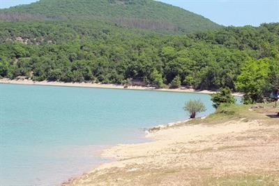
: Akhtarsko-Grivenskie, Chernoerkovsko-Sladkovskie, Kurchanskie, Zhesterskie, etc. There are significantly more lakes in the foothills and mountainous areas. The largest is Lake Abrau. Lake Abrau is located on the southwestern slope of the Main Caucasus Range, in the southern low part of the river valley. Abrau (Novorossiysk). Lake Abrau belongs to the type of terminal (mouth) lakes. The catchment area is 20.3 km2, the surface area is 1.6 km, the water volume is 9.3 million m, average depth
- 5.8 m, the highest reaches 10.4 m. The water in the lake has no taste or smell. The second largest mountain lake is Kardyvach. At the source of the river Mzymta, 44 km from the village. Krasnaya Polyana, there is a group of Kardyvach lakes, of which lake. Kardyvach is the biggest. Lake area - 133 thousand m2,- 17 m. Located on the border of forest and subalpine zones at an altitude of 1837 m above sea level. The lake is under ice for 7-8 months a year, the water temperature does not exceed 12°C. [Report...2013, p. 45].
A special feature of the region is the presence of estuaries among the reservoirs, total number of which there are 300. The system of estuaries of the Krasnodar Territory is presented in Figure 3.
Fig 3
Estuaries are shallow bodies of water, their average depth ranges from 0.5 to 2.5 m, they were created by the seas washing the region, steppe rivers and the river delta. Kuban. Most estuaries have low-lying, gently sloping banks covered with moisture-loving vegetation. The estuaries of the Azov region are separated from the sea by estuaries, low spits, through which they roll during slight waves. sea waves, so the water of these estuaries is salty. The estuaries of steppe rivers that do not reach the sea have fresh water. As a result of the death of vegetation and river sediments, many of them gradually silt and become shallow.
The largest estuaries are located on the coast of the Azov Sea: Beisugsky, Akhtarsky, Grivensky, Kirpilsky, Akhtanizovsky, Yeysky, Cheburgolsky, etc. On the Black Sea coast, the largest are located between Taman and Anapa - these are Kiziltashsky, Vityazevsky, Bugazsky, Tsokur.
The estuaries of the Azov region are rich in food and are convenient spawning grounds for fish. In some estuaries they mine healing mud(Vityazevsky estuary). Part of the floodplain zone of the Kuban delta and some estuaries have been drained and turned into rice paddies. More than 80% of the rice in the Russian Federation is produced here [Nagalevsky Yu.Ya., 2001, p. 123].
The Krasnodar region has been a subject of the Russian Federation since 1937. It is located in the southwest of the country and is part of the Southern Federal District.
Types of reservoirs
In order to move on to the description of the reservoirs of this territorial unit of the Russian Federation, it is necessary to clarify what this concept is.
A reservoir is a temporary or permanent accumulation of water, standing or with reduced flow, in natural or artificial depressions. This term also applies to seas and oceans, but in a broader sense. Oxbow lakes and puddles can be called temporary, that is, those hydraulic objects that arise during certain periods of the year, most often during spring and autumn floods.
Reservoirs of the region
Permanent objects of this type include lakes, ponds, reservoirs and specific reservoirs of the Krasnodar Territory - estuaries. Reservoirs are divided into artificial and natural. The first include reservoirs, dams, ponds and pools.

All of the above hydro objects are available in Kuban, most which occupies the Krasnodar region. In the southwest and northwest, the territory of the region is washed by the waters of the Black and Azov seas respectively. These are the largest natural reservoirs in the Krasnodar region.
Seas of the Krasnodar Territory
The Black Sea is washed by the border of the region from which serves as the border with Abkhazia to Cape Tuzla. The Kerch Strait connects it with the Sea of Azov, which is 11 times smaller in area than the Black Sea. The Sea of Azov is the smallest sea in Russia. In ancient times it was called the Maeotian swamp.

These reservoirs of the Krasnodar Territory differ sharply from each other. Thus, the greatest depth of the Black Sea is 2210 (2245) meters, while the Sea of Azov is only 14. The water in the first is very salty and below 200 meters is saturated with hydrogen sulfide, while in the second natural reservoir she, desalinated large rivers- Kuban and Don, contains little salt. The shores of the Black Sea are covered mainly with pebbles, while the shores of the Azov Sea are covered with shell rock and sand. And if in the Black Sea there are up to 180 species of fish, 40 of which are commercial, then the Azov Sea, until recently, was generally considered the richest in fish reserves in the country.
The largest freshwater lake
In addition to seas, large natural hydrological objects include lakes. Abrau, Kardyvach and Psenodakh are fresh reservoirs of the Krasnodar Territory of this type. The largest freshwater closed lake in the Krasnodar Territory is the Abrau reservoir, located on the peninsula of the same name (Abrausky), 14 km from Novorossiysk. The reservoir is indeed large - its length is 3,100 meters, width - 630. The depth in some places reaches 11 meters.

The area of the mirror is 0.6 square kilometers. Scientists argue about its origin - some consider it karst, others - formed as a result of a landslide. There are suggestions that the lake is a remnant of the ancient Cimmerian freshwater basin. The lake is very clean, as evidenced by the presence large quantities crayfish on the banks. In addition to them, it is also found here. As noted above, the lake is drainless, and only one river flows into it - Durso, as well as numerous mountain streams. And yet, without natural drainage, the lake becomes shallow. It becomes shallow and silts up, despite the measures taken. Next to it there is a small Dolphin Lake, the depth of which reaches 7 meters. It is adapted for working with marine animals - a dolphinarium has been built here.
The name of the reservoirs of the Krasnodar Territory, each of them, sounds very beautiful and mysterious and is often shrouded in some kind of legend. Lake Abrau and the Durso River flowing into it, combined in the name of the rural district, are associated with a beautiful legend about unhappy love. And the name of the second largest reservoir in the Krasnodar Territory, Lake Kardyvach, is translated from the Abaza language as “in a clearing inside a hollow.”
Lake Kardyvach
All reservoirs of the Krasnodar Territory are beautiful; Kardyvach is often called the lake of dreams. Located 44 km from the now world famous resort of Krasnaya Polyana, located at an altitude of 1838 meters above sea level, this is almost the right oval shape the pond is a favorite place for tourists and part of biosphere reserve. The lake is often called mirror - in it, except beautiful shores, snow-capped mountain peaks are reflected.

The river flowing from it is the longest of all the rivers and streams flowing into the Black Sea. The length of the lake reaches 500 meters, width - 360, depth - 17 meters. It should be added that the lake, located on the southern slope of the Main Caucasus Range, changes color - from emerald green in spring to bright blue in summer.
Lake Psenodakh
The third largest lake is the lake of the Lago-Naki plateau - Psenodakh, located at an altitude of more than 1900 meters. The shape of this lake is interesting - it resembles a smile. The reservoir is shallow - no more than a meter (the greatest depth reaches 3 m). The lake is interesting because periodically, and often for unknown reasons, it disappears and then appears again. And when it is there and filled with water, it presents an amazingly beautiful sight - surrounded by meadows and framed by mountain peaks, it is filled with clear and clean water.
Other lakes of the Krasnodar region
Near the Black and Azov Seas there are salt lakes, which were formed as a result of the appearance of an alluvial ridge that separated the reservoirs from the sea. The healing mud found in lakes such as Khanskoye, Golubitskoye and Solenoye, Chemburka and Sudzhukskoye are used for medicinal purposes. The same salty lakes with healing mud are also found in steppe zones- near Armavir there are two Ubezhensky lakes - Maloe and Bolshoye.

There are lakes like Old Kuban, which was formed from the old bed of the Kuban River. It is interesting because its waters are used to cool the Krasnodar Thermal Power Plant. It is also used for fish breeding, and in Lately recreational purposes (swimming and recreational fishing).
Estuaries
Natural reservoirs of the Krasnodar Territory are also a huge array of lagoon and floodplain natural reservoirs, called estuaries. They are located at the mouth of the Kuban River and occupy an area of 1300 square meters. km. Their depth ranges from 0.5 to 2.5 meters. They occurred as a result of processes of formation of a river delta on the site of a sea bay. This happened as a result of the formation of a shell spit, which fenced off the bay from the seas - the Black and Azov. There are many of them - some are listed below, and Kiziltashsky, Yeisk, Beysugsky and Kirpilsky have always been considered the largest. The entire massif of Kuban estuaries is divided into three systems - Taman, Central and Akhtarsko-Grivenskaya. They combine both lagoonal estuaries located near the sea, and floodplain ones - remote from it. There are edges and floodplains on the territory.
Reservoirs
Artificial reservoirs of the Krasnodar Territory are represented by the following reservoirs - Atakaisky and Varnavinsky, Krasnodar and Kryukovsky, Neberdzhaevsky and Shapsugsky.
In the Kuban basin alone in the Krasnodar Territory there are 10 reservoirs. The largest not only in the region, but throughout the entire North Caucasus is the Krasnodar reservoir, which was finally filled with water and put into operation in 1975. It swallowed up the Tshchikskoe reservoir that was previously located here. The purpose of its formation was to combat floods in the lower reaches of the Kuban (such tributaries of the Kuban as Belaya, Pshish, Marta, Apchas, Shunduk, Psekups flow into it) and rice growing.
Protection and use
The use and protection of reservoirs in the Krasnodar Territory is carried out by services of various departments. Thus, reservoirs are used to maintain required level water for navigation. All reservoirs, except salty ones, are used to irrigate areas with insufficient moisture, to ensure normal watering of fields, including rice fields.

The condition of reservoirs is constantly monitored within the framework of sanitary and epidemiological surveillance and monitoring. The state of water quality is monitored at 297 sampling points. 42 are located on reservoirs of category I (household and drinking supply), 136 - category II (swimming, sports, recreation for the population), 119 - category III (fishery purposes). From May 15 until the end of the summer holiday season, laboratory control water quality. Constant explanatory work is being carried out with the population about the inadmissibility of polluting water bodies.
Bad ecology
The ecological state of reservoirs in the Krasnodar Territory is determined on the basis of information received by control authorities. It can be stated that there are plenty of problems in the region’s water bodies. These include depletion of fish stocks, degradation of water bodies - shallowing, silting, overgrowing of estuaries, waterlogging. Coastal erosion, discharges of prohibited urban waters, contamination natural environment toxic industrial waste, as well as radioactive contamination of the territory and much more even resulted in the fall acid rain. The greatest changes in the Krasnodar Territory occurred as a result of water-chemical reclamation, which negatively affected the condition of the soil - due to its oversaturation, up to 50% of chemical fertilizers were washed into water bodies, which could not but lead to disastrous results.
The amazing Lake Kardavych is located in a natural basin and is surrounded on all sides by the mountain slopes of Tsyndyshkha, Loyub, Kuteheku.
The lake is of moraine origin, formed due to the movement of ancient glaciers. It has an ellipsoidal shape, and the size is 500 meters in length and about 300 in width. The water in the lake is cold at any time of the year; even on the hottest day its temperature does not rise above 10 C.
The most long river in Russia - the Mzymta, which flows into the Black Sea, originates from Kardyvach.
Anyone who has ever visited the lake, breathing in the purest mountain air, receives only the most wonderful and unforgettable impressions at this place. Beautiful meadows grow around Kardyvach, pink clouds float past, and rhododendrons growing everywhere will not leave anyone indifferent.
The most remarkable thing is that the lake is completely fishless. This is connected with the Emerald Waterfall, located downstream. Not a single mountain trout can cross its water flow.
Salt Lake
The salt lake is small in size, it is located on the southern shore Taman Peninsula, in the Temryuk district of the Krasnodar region. It is considered one of the saltiest in the region. The lake attracts tourists who want to wallow in the mud for medicinal purposes. In the summer, due to drying out, black mud swamps form around the lake, which are full of people. In places where the mud dries out, white salt crystals form on it.
The lake is located next to the Black Sea, they are separated by the Anapa embankment. Probably water entered the lake from the sea, and over time, marine mineral substances became concentrated in it.
Lake Abrau
Lake Abrau is located in the quiet and cozy village of Abrau-Durso with a population of about 4,000 people, reminiscent of little Switzerland. The village is famous for its winemaking and viticulture.
The main attraction of the village is the large Lake Abrau, the origin of which is still not exactly clear. Some believe that the lake was formed from an ancient fresh sea, but most versions agree that the lake arose from a sinkhole.
The lake lies at an altitude of 84 meters and is surrounded by mountains with rounded peaks and gentle slopes. In the 50s, life was in full swing on the lake: reeds grew along its shores, where birds made nests, muskrats lived there, and fish spawned. But later the lake was cultivated, and after human intervention it began to silt up. Now the depth of the lake reaches 10 meters, although more recently it reached 35 meters.
Snake Lake
Snake Lake - a freshwater lake in the vicinity of the village Big Utrish. The lake is connected to the Black Sea, but is a unique natural monument. Today there is a yacht club and a parking lot here.
total area The lake exceeds 20 hectares, and the depth in some places exceeds 7 meters. The shores of the lake are surrounded on one side by a small juniper grove, and on the other by rocks directly approaching the ridges Caucasus Mountains.
Historically, Snake Lake was a secluded freshwater body of water, separated from the sea by a narrow isthmus. There was a lake in the lake great amount snakes, from which it got its name. Subsequently, the isthmus was razed, and the lake was connected to sea waters.
Kuban River Basin
In terms of size and water content, the Kuban River basin is the largest in the North Caucasus. It stretches from the Taman Peninsula in the west to Elbrus in the east. Kuban flows into the Sea of Azov. Its source is taken to be the confluence of rivers Uchkulan and Ullukam. With a catchment area of 57900 sq. km. the total length of the rivers in the basin is 38,325 km, and the total number of rivers is 13,569. The length of Kuban itself is 870 km.
In the river basin, almost all tributaries originate from the slopes of the Western Caucasus, flowing from the left bank. Major tributaries include: Laba(catchment area 12,500 sq. km., river length 214 km), White (5990, 265), Big(2730, 120) and Small (1850, 65) Zelenchuk, Urup (3220, 232), Pshish(1850, 258), etc.
The Kuban River is fed by melting glaciers, seasonal snow, rain and groundwater. Most of the tributaries originating in the high-mountain zone of the basin are Big and Small Zelenchuk, Kizgych, Teberda, Ullukam and others - receive glacial nutrition.
The water regime of the Kuban River is divided into 3 hydrological regions:
- rivers upstream(to the river mouth Bekes) inclusive;
- river basins Chamlyk, Fars, Belaya;
- tributaries of the lower reaches (from the confluence of the river. Pshish to the mouth);
In the first region, waters formed due to the melting of glaciers and snowfields play a large role in feeding the rivers. For the second important role rain floods play.
Rivers of the Azov-Kuban Lowland
The Eya River is the longest and most abundant river Azov-Kuban lowland. It originates at the spurs Stavropol Upland, 5 km from the village Novopokrovskaya and is formed from the confluence of two small rivers Karasuna and Upornaya. The Eya River flows into the Sea of Azov below the village of Staroshcherbinovskaya. Its length is 311 km. The total area of the drainage basin is 8650 sq. km. The largest right-bank tributary is Kugo-Eya, having a length of 108 km with a catchment area of 1260 sq. km. Another major influx is Kavalerka River, 78 km long and a drainage area of 695 sq. km. On the left it flows into Eyu Sosyka River, having a length of 159 km and a drainage area of 2030 sq. km., as well as small Ternovaya and Veselaya rivers.
There are numerous ponds on the Eya and its tributaries; they are used for watering, fishing and energy. The high mineralization of Eu makes it unsuitable for irrigation
The Chelbas River flows southwest of Eya. The source of the river is located near the northern outskirts of the village Temizhbek. The length of Chelbas is about 288 km, the area is 3950 sq. km. It flows into the Beysugsky estuary. Main tributaries: Middle Chelbas, Borisovka and Tikhonkaya. Average annual consumption at the village Novoplatnirovskaya 2.41 m3/s.
About 120 ponds were built on the Chelbas River. Heavily overgrown and silted Chelbas reveals shining example a river in a state of old age and decline.
Beysug River - third longest and second largest of the rivers Azov region. Its sources are springs located 9 km northwest of Kropotkin. The Beysug flows into the Beysug estuary near the village Brinkovskaya. Its length is 243 km, the catchment area is 5190 sq. km. The most significant tributaries: Beysuzhek left and Beysuzhek right. The width of the river bed in the upper reaches reaches 200 m with a bank height of 5-7 m. In the middle reaches, the width of the river bed is 400 m. In the lower and middle reaches, the Beysug is very winding, sometimes forming wide reaches, bays and oxbow lakes. Below the village Bryukhovetskaya the floods are coming. The river is fed by precipitation and springs.
Kirpili River- It starts 7-8 km northwest of the village Ladoga and flows into Kirpilsky estuary 10 km north of the village Stepnoy. The length of the river is 202 km, the drainage basin area is 2650 sq. km. Tributaries: Kochety and Kirpilitsy . The bricks meander strongly, and its bed is mostly covered with reeds. This is a low-water river, its average annual flow near the village is Medvedovskaya
is about 2 m3/s. There are about 100 ponds in the river basin for agricultural and fishing purposes.
Rivers of the Black Sea coast Within the Krasnodar region from the dense southern slopes Greater Caucasus , covered dense forests , rapidly carry their waters into the Black Sea by hundreds of fast mountain rivers
. However, it is worth noting that local residents dump their sewage and any garbage into them, which accordingly flows into the sea. The most mineralized river in the Black Sea basin: Gotagay
940 mg/l. Psou River flows on the border between Russian Federation and Abkhazia, unrecognized by the world community. Starts west of Agepsta mountains , at an altitude of about 2730 m and flows into the Black Sea, 3 km southeast of Adler . Major tributaries: Psycho And Besh
. The river is fed by snow and rain. The annual flow is about 650 million m3. Mzymta - translated from Circassian as “Mad”. And it fully lives up to its name! Beginning of the shore near the mountain Loyub , at an altitude of 2980 m. Flows into the Black Sea near Adler. Mzymta is very picturesque. Two kilometers from the source it flows into Lake Kardyvach. There are several waterfalls on the river, the highest is 15 m. The largest tributaries: Psluh, Pudziko, Chvezhipse . On its way, Mzymta crosses the following ridges:, Aibga-Achishkho Atskhu-Katsirkha and Akhshtyr . Very picturesque gorge Atskhu . Near the village Krasnaya Polyana
Krasnopolyanskaya hydroelectric power station was built on Mzymta. The power of the hydroelectric power station is 28 thousand kW. Sochi River starts near the mountain
Chura at an altitude of 1313 m and flows into the Black Sea near Sochi. The average annual river flow near Sochi is about 17 m3/s. Floods are common in spring and winter. Pshada River- a small mountain river that originates near the mountain Pshada
at an altitude of 448 m and flows into the Black Sea. There are more than 10 waterfalls on Pshad, the highest among them is Bolshoi Pshadsky (Olyapkin) waterfall. Shah Sochi River- the second largest river on the Black Sea coast within the Krasnodar Territory. It starts with Main Caucasus Range near the mountain at an altitude of 1718 m, in the zone alpine meadows and flows through Lazrevsky district of Greater Sochi , flowing into the Black Sea near the village Head
. Almost the entire Shakhe River basin is covered with forest and runs through the mountains. Major tributaries:
The number of lakes in the Krasnodar region, according to various sources, exceeds three hundred. They are scattered in a variety of places: in the valleys through which steppe rivers flow; along the coastlines of the Black and Azov seas; in the lower reaches main river edges - Kuban; among the majestic and high Caucasus Mountains on almost a third of our territory.
Here you can enjoy fishing, hunting, and medical procedures.
Why are our compatriots and foreign guests so actively trying to fly and come to us? Let's give these interesting numbers- after Winter Olympic Games In Sochi, Krasnaya Polyana alone with its now world-famous ski resort was visited by over a million tourists. And this is only for one season!

At the resorts of the Black and Azov Seas, more than fifteen times more Russians and citizens from near and far abroad countries, including children, receive treatment and rest. And what? Excellent ski slopes, not inferior to those in Switzerland, excellent sandy and pebble beaches, equipped no worse than European ones, no problems with accommodation, food, etc. Finally - safety! Why strive for rest and treatment abroad, when in your own country the conditions are no worse, and in some places even better! In addition, among the vacationers arriving to us, be they adults different professions or university, college, teenage secondary school students educational schools There are many fans of leisure time by the lake - with a spinning rod in hand. If desired, you can also catch waterfowl or animals with valuable fur - muskrat, nutria, beaver, and so on. And some tourists specifically come to the region, knowing well about healing power some of our lakes.

For the information of guests - lovers of biting or spearfishing - in the lakes of the region there are more than one hundred and fifty species of fish: carp, crucian carp, rudd, bream, tench, roach, carp, silver carp, lake trout - you can’t list them all. And since 1971 it appeared the new kind- largemouth buffalo. It's new for us, of course. His homeland is North America, lakes between southern Canada and Mexico. The fish also has another name - ictibus, a species of the Chukuchanov family. to his appearance The largemouth buffalo resembles carp, crucian carp, and silver carp. Some specimens weigh several kilograms. They make a rich, excellent soup. I caught it during the day with a fishing rod, and in the evening, if you also set up a tent on the shore with the intention of spending the night, lit a fire on the shore and cooked it sweet, fragrant, with various aromatic spices - delicious! But avid fishermen need to know that fishing here is possible, excluding the period from March 1 to May 31, and, for example, on the Khanskoye reservoir - from March 31 to June 15, when the fish spawn. For some breeds, the fishing dates shift in one direction or another, but generally remain practically within the framework indicated above. The region also regulates the timing of harvesting waterfowl and animals with valuable fur that live in lakes. You can find out about the deadlines directly at your vacation spot in order to insure against all sorts of misunderstandings and avoid fines and other administrative penalties for illegal fishing and production.
-

The largest local lake with fresh water is Abrau. It is 3 kilometers long and 630m wide. It can be found on the Abrau Peninsula, 14 kilometers from Novorossiysk. His name is also used local factory for the production of famous champagne wines "Abrau-Durso".

If we talk about facts, then this is one of the lakes that decorate the Krasnodar region. This has already been recognized, since the Bottomless is approved as nature reserve. You can find it in the basin of the local river Aderby if you look in the left slope of its large valley.

“Mirror in the Mountains” is the best way to describe Achipsta. It immediately comes to mind; it’s worth looking at the bird’s-eye shots. Getting to it is also not easy; the lake is reliably protected on all sides by green hills, and it is high, more than 1860m above the sea.

It certainly owes its mysterious name to local residents. Only they can leave new topics for thought for posterity. Yes, there are many legends about Witch Lake, passed down through generations. Most people are united by two facts: the lake has no exact depth, because there is no bottom; it was once bewitched by witches.

It fully justifies its name - the water in Zerkalny is transparent, pleasingly clean and greenish. There are no mysterious and ominous legends about him either. Most likely, it was once called that only due to the natural properties of water. The banks are easily accessible, they are gentle and level, and you don’t need to go near the water for a long time.

They're so beautiful there magical places, that even on the way to it you can safely make a film, a real science-fiction thriller without any additional scenery. It’s enough just to see these tree trunks overgrown with greenery, a path covered with leaves somewhere ahead...


It is also called Maly Liman. The lake enters the treasury natural resources region, a real monument, only natural. People try to preserve such places in their original form, without interfering. Limanchik belongs to the territory of the Abraussky reserve; it is as much as 7100 hectares of real rarities; every tourist should visit it.

It has a Circassian name meaning “beautiful well”, and if translated from Adyghe - as “beautiful lake”. Indeed, having been there, it is difficult to argue with the ancestors - the beauty of the place is quite difficult to over-praise even for an experienced poet or novelist.

The lake itself is a closed system without channels; it is a natural lagoon, separated by a low and long embankment from the Beisugsky estuary, its closest water neighbor. The lake has shallow waters, sandstone islands and mudflats. Khansky's shape is oval, without sharp bends.

The lake owes its name to the geographer, famous writer and the scientist Y. K. Efremov, who studied the Krasnodar region. The name is in honor of the name of another scientist, V.F. Khmelevsky, who owned several plots of land near local lakes, and was himself engaged in climate research and the inhabitants of Krasnaya Polyana.
-

This is undoubtedly the most mysterious and curious of the places in the Western Caucasus. It can be found between the mouths of the two rivers Pshekhashka if from the east and Tugups with Shakhe if from the west. Huko also rich story associated with his name. Scientists have put forward two explanations for the origin of the name.
There are many lakes - don't get lost!
There are lakes in Kuban, both large and small. Khansky has as much as eighteen meters to the bottom. The largest freshwater lake in size is Abrau. It is approximately fourteen kilometers from Novorossiysk. Its length is 3100 meters, width - 630 and depth up to 11 meters. But Lake Khanskoe (Tatar), although longer (16 kilometers) and much wider than Abrau (6-7 kilometers), is not deep at all - just over eighty centimeters. Compared to them, Lake Golubitsoe on Taman is completely Lilliputian: its area is 0.6 square kilometers, 140 meters wide and up to one and a half meters deep. But there are tons of people there during the holiday season! Why? A little more detail later.

Let's name the most famous lakes of the region, besides Abrau and Khansky: Abinskoye (Lesnoye), Mertvoye ( Hot key), Khuko (near Lagonaki), Chernoe (stanitsa Akhmetovskaya). Only in the surrounding area ski resort Krasnaya Polyana has more than a dozen lakes: Nipsey, Achipsta, Dzitakskie, Kardivach, Atsetukskie lakes, etc.
Above we mentioned Lake Golubitskoye. It makes sense to talk about it in some detail: it is priceless for its medicinal qualities. Located next to the village of the same name. And almost a hundred meters from the Sea of Azov. Its depth varies depending on the seasons. In summer, from one and a half meters it can drop to 0.5-0.8 meters. In any case, you will not drown in it. But the main thing is to dive into it and grab the silt deposits into the container, which are black mud saturated with hydrogen sulfide with iodine, calcium and other chemical elements. The dirt was formed from rotting algae, dead microorganisms, crustaceans, and the like. With an undisguised smile, you watch how, having taken out the mud from the bottom, the vacationers smear it from head to toe, their faces are like those of blacks, only their eyes shine. And people know what they are doing: silt deposits treat skin diseases and are useful for diseases of the musculoskeletal system. A few days of such procedures, and your skin becomes smooth, like a baby’s, and heals without a trace of a wound. And it becomes much easier for the legs. And it’s easy to wash off the dirt - here is the sea, very close, plunged into its waves, and is clean, like after a bath or shower. And the lake water is healing, with 40 grams of healthy salts per liter. In combination, mud and water treat radiculitis and rheumatism and other diseases of the spine, they are also useful for the skin and the musculoskeletal system, they will heal your nerves and cardiovascular system and other diseases. IN high season The lake is crowded, but there is enough room for everyone! By the way, many tourists combine treatment with the mud and water of Lake Golubitskoye with excursions. In particular, to the Valley of Lotuses, delicate flowers from India, which have taken root well in the desalinated Akhtanizovsky Estuary. Pink flowers in July - August there is no end and end - they delight the eye on an area of one by half a kilometer! To what has been said, it must be added that in the same Taman there are several lakes with healing water and mud - Solenoye in Veselovka, already named by us Khanskoye (Tatarskoye), etc.
The lakes in Kuban, located among the mountains, are of indescribable beauty. One of them is Kardyvach - on the territory of the Caucasian Biosphere Reserve at an altitude of 1838 meters above sea level, 44 kilometers from Krasnaya Polyana. A wide basin, above it rise the peaks Loyub (2970 meters above sea level), Tsyndyshkha (3195 m). The longest river flowing into the Black Sea, Mzymta, originates from the lake. It flows through a gorge with extreme attractions - giant swings, jumping into the abyss on an elastic rope from the world's longest man-made suspension bridge, but this is a separate conversation. There are no fish in the lake. But what a magnificent view around it! Woodlands go straight down to the shore. Tall grasses, flowers, natural aromas make your head spin. Reserved place- for lovers of active tourism. I can’t describe the impressions!
If you are lucky enough to visit Krasnaya Polyana one day, do not miss to admire the beauty of another high-mountain lake - Khuko! It is located six kilometers from Mount Fisht and between the rivers Pshekhashkhe and Shakhe. Near the lake the poetic translation is “Dolphin”, and one of the peaks nearby really resembles the figure of this smartest man on earth sea creature. Some indigenous people call the lake “Son of the Sea”. For the Circassians, the reservoir is sacred. There is a rumor that it is somehow connected with the Black Sea, and is a tiny piece of the remnant of the world ocean Titis, which once rolled its mighty waters here. Another belief is that Huko can cause rain. During drought, this is much needed magic! The lake is not large - its area is 27.5 thousand square meters, length 260, width 150 and maximum depth 10 meters. The shape is similar to an oval. The surrounding mountains are overgrown with beech, there are subalpine plants, the landscape is very picturesque. There are no fish or algae in the lake. But there are excursion routes here, and anyone can get here and admire the local beauties.
Needless to say, there are a great many lakes in the Krasnodar region: along the coasts of the Black and Azov Seas, on the Kuban Plain, in the massifs of the Great Caucasus Mountains. Dozens of them have excursion routes from resort towns and villages. So each guest has a wide choice of which lake to go to and what to do there. Take advantage of this opportunity, and you will learn about Kuban not only as a seaside federal health resort, but also as a fertile land with beautiful fresh and salt water bodies - lakes, where you can fish, hunt or just admire their fabulous unique beauty!
Why is it worth going somewhere far away in search of unusual and beautiful places? IN native land There are a lot of them, wouldn’t you like to know more about them? Lake Sukko in the Anapa resort is one of them. It is located next to an entertainment center that is already known far beyond the country's borders.


Kuban is rich in Natural resources. Not far from the Bugaz estuary there is Salt Lake, which gives people the opportunity not only to enjoy beautiful view, but also to treat various diseases.