The concept of relief, its classification, relief formation factors. What is relief? We define the concept
relevo - raise) - a set of hard irregularities the earth's surface and other solid planetary bodies, various in shape, size, origin, age and development history. Consists of positive and negative forms. The relief is the object of study of the science of geomorphology.Collegiate YouTube
1 / 3
✪ Geography 9. Features of the Earth's relief - Academy of Entertaining Sciences
✪ Geography 49. Landforms of the Earth. Wrangel Island - Academy of Entertaining Sciences
✪ Issue 15 - Extraterrestrial relief. Record and unusual details.
Subtitles
Terrain levels
In geomorphology, three levels of relief are distinguished: relief elements, relief forms and relief complexes.
Relief elements
Relief elements- these are the simplest components of the relief: points, lines and surfaces. The surfaces, or faces, of the relief are referred to the elements of the first kind, and points and lines to the elements of the second kind. Relief elements of the second kind are formed when two (lines) or more (points) elements of the first kind intersect.
In shape, the elements of the first kind of relief can be flat, convex, concave and combined (convex-concave, concave-convex, wavy, stepped, etc.). In terms of steepness (inclination), among the elements of the first kind, horizontal (0 °, 5% of the Earth's land), subhorizontal (more than 0 ° to 2 °, 15% of the Earth's land) and slopes (more than 2 °, 80% of the Earth's land) are distinguished.
Lines, or edges, of the relief divide surfaces that fall in different directions (thalweg, watershed) or surfaces of different steepness that fall in one direction (edge, rear seam (sole, foot)).
The relief points include mountain peaks and the bottoms of cone-shaped funnels.
Landforms
Landforms- concrete irregularities of the earth's surface, which is a surface that encloses a three-dimensional volumetric body and consists of relief elements or simpler relief forms. Landforms can be simple and complex, positive and negative, open and closed.
Relief complexes
Complex (type) of relief- this is a set of landforms that are similar in some way: externally (morphologically), in origin (genetically), in age.
Genesis (origin) of the relief
The relief is formed and develops mainly as a result of long-term simultaneous impact on the earth's surface of endogenous (internal) and exogenous (external) processes. The processes that form the relief are called relief formation agents.
The main source of endogenous processes is thermal energy bowels of the Earth. It causes tectonic movements of the earth's crust, which are accompanied by the formation of faults, movement of crustal blocks, folding and magmatism.
The main source of exogenous processes is the radiant energy of the Sun. On the earth's surface, it turns into the energy of water, air, lithosphere matter. The relief is formed under the influence of flowing waters, water masses oceans, seas and lakes, wind, ice, dissolution rocks... Exogenous include slope processes, cosmic forces, as well as the vital activity of organisms and economic activity person.
Relief age
The most important task geomorphology is the determination of the age of the relief. Relief age- this is the time (or past) of the activity of the relief formation agent, which formed the unevenness and gave it its main features. In geomorphology, as in geology, absolute and relative ages are used.
Relative age can be considered in several aspects. V. Davis argued that the development of relief is a stage-by-stage process, therefore, for each form of relief, one can distinguish an initial stage, stages of adolescence, maturity and old age (decrepitude). On the other hand, it is possible to determine the age in comparison with other landforms. Then they use the words younger, older (older). You can also use the Geochronological Scale to determine the relative age.
The absolute age of the relief is determined in years. This became possible thanks to the development modern methods: radioisotope, paleomagnetic.
Relief functions
The relief is essential component geographic envelope... First, the relief is the basis for natural territorial complexes (NTC). Secondly, the relief redistributes moisture and heat (that is, matter and energy) over the earth's surface.
Studying geography and topography, we are faced with the concept of terrain. What is this term and what is it used for? In this article we will understand the meaning of this word, find out what types there are, and also much more.
Relief concept
So what does this term mean? Relief is a set of irregularities on the surface of our planet, which are composed of elementary forms. There is even a separate science that studies its origin, development history, dynamics and internal structure. It is called geomorphology. The relief consists of separate forms, that is, natural natural bodies that represent its individual parts and have their own dimensions.
Variety of shapes
According to the morphological principle of classification, these can be both positive and negative. The first of them rise above the horizon line, representing an uplift of the surface. An example is a hillock, hill, plateau, mountain, and so on. The latter, respectively, form a depression relative to the horizon line. These can be valleys, beams, depressions, ravines, etc. As mentioned above, the relief form is composed of individual elements: surfaces (edges), points, lines (edges), corners. According to the degree of complexity, complex and simple natural natural bodies are distinguished. The simple forms include hillocks, hollows, hollows, etc. They are separate morphological elements, the combination of which forms a form. An example is a bump. It is divided into such parts: sole, slope, top. A complex form consists of a number of simple ones. For example, a valley. It includes the riverbed, floodplain, slopes, and more.

According to the degree of slope, sub-horizontal surfaces (less than 20 degrees), inclined and slopes (more than 20 degrees) are distinguished. They may have different shape- straight, convex, concave or stepped. According to the extent of their extension, it is customary to divide them into closed and open.
Types of reliefs
The combination of elementary forms that have a similar origin and extend over a certain space determines the type of relief. In large areas of our planet, it is possible to combine several certain types based on similar origin or difference. In such cases, it is customary to talk about groups of relief types. When the association is made on the basis of their formation, then they talk about genetic species elementary forms. The most common types of land relief are flat and mountainous. In terms of height, the first are usually divided into depressions, hills, lowlands, plateaus and plateaus. Among the latter, medium and low are distinguished.

Flat relief
This area is characterized by insignificant (up to 200 meters) relative elevations, as well as a relatively low steepness of the slopes (up to 5 degrees). The absolute heights are small here (only up to 500 meters). These areas (land, the bottom of the seas and oceans), depending on the absolute height, are low (up to 200 meters), elevated (200-500 meters), upland or high (over 500 meters). The relief of the plains depends primarily on the degree of ruggedness and soil and vegetation cover. It can be loamy, clayey, peaty, sandy loamy soils. They can be cut by riverbeds, gullies and ravines.
Hilly terrain
It has a wavy character, forming irregularities with absolute heights up to 500 meters, relative elevations up to 200 meters and a steepness of no more than 5 degrees. The hills are often made of hard rock, and the slopes and peaks are covered with a thick layer of loose rock. The lowlands between them are flat, wide or closed basins.
Hills
Mountainous terrain is a terrain that represents the surfaces of the planet, significantly elevated relative to the surrounding area. It is characterized by absolute heights from 500 meters. Such a territory is distinguished by a varied and complex relief, as well as specific natural and weather conditions... The main forms are mountain ranges with characteristic steep slopes, which often turn into cliffs and cliffs, as well as gorges and hollows located between the ridges. Mountainous areas of the earth's surface are significantly elevated above sea level, while they have a common base that rises above the adjacent plains. They consist of many negative and positive landforms. According to the level of height, it is customary to divide them into low mountains (up to 800 meters), medium mountains (800-2000 meters) and high mountains (from 2000 meters).
Relief formation
The age of the elementary forms of the earth's surface is relative and absolute. The first establishes the formation of a relief relative to some other surface (sooner or later). The second is defined using The relief is formed through the constant interaction of exogenous and endogenous forces. So, endogenous processes are responsible for the formation of the main features of elementary forms, and exogenous, on the contrary, tend to align them. In relief formation, the main sources are the energy of the Earth and the Sun. One should not forget also about the influence of space. The formation of the earth's surface occurs under the influence of gravity. The main source of endogenous processes can be called the thermal energy of the planet, which is associated with radioactive decay happening in her mantle. So, under the influence of these forces, the continental and oceanic crust was formed. Endogenous processes cause the formation of faults, folds, movement of the lithosphere, volcanism and earthquakes.

Geological observations
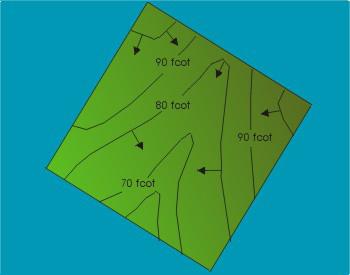
Geomorphologists are studying the shape of the surface of our planet. Their main task is to study geological structure and the terrain of specific countries, continents, planet. When drawing up a description of a particular area, the observer must determine what caused the surface shape in front of him, to understand its origin. Of course, it will be difficult for a young geographer to figure out these issues on his own, so it is better to seek help from books or a teacher. When compiling a description of the relief, a team of geomorphologists must cross the area under study. If you need to draw up a map only along the route of movement, then you should maximize the observation lane. And in the process of research, periodically move away from the main path to the sides. This is especially important for poorly visible areas, where forest or hills obstruct the view.

Mapping
Writing down information general(the terrain is hilly, mountainous, heavily rugged, etc.), it is also necessary to map and describe separately each element of the relief - a steep slope, a ravine, a ledge, a river valley, etc. Determine the dimensions - depth, width, height, angles of inclination - often, as they say, by eye. Due to the fact that the relief depends on the geological structure of the area, while conducting observations, it is necessary to describe the geological structure, as well as the composition of the rocks that make up the studied surfaces, and not only their appearance... It is necessary to mark in detail karst sinkholes, landslides, caves, etc. In addition to the description, it is necessary to carry out schematic sketches of the study area.
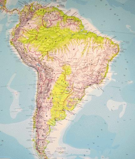
By this principle, you can explore the area near which your home is located, or you can describe the relief of the continents. The methodology is the same, only the scales are different, and it will take much more time to study the continent in detail. For example, in order to describe, you need to create a set research groups, and even then it will take more than one year. After all, the aforementioned continent is characterized by an abundance of mountains stretching along the entire continent, Amazonian virgin forests, Argentine pampas, etc., which creates additional difficulties.
Notes for a young geomorphologist
When compiling a relief map of the area, it is recommended to ask local residents where you can observe the places where the layers of rocks and groundwater emerge. These data should be entered on the terrain diagram and described in detail and sketched. On the plains, the rock is most often exposed in places where rivers or ravines have cut the surface and formed coastal cliffs. Also, these layers can be observed in quarries or where there is a highway or Railway passes through the cut out recess. The young geologist will have to examine and describe each layer of the rock, starting from the bottom. Using a tape measure, you can take the necessary measurements, which should also be entered in the field book. The description should indicate the dimensions and characteristics of each layer, their serial number and exact location.
RELIEF RELIEF (French relief, from Latin relevo - I raise), a set of forms of the earth's surface, differing in shape, size, origin, history of development. The relief is formed mainly as a result of long-term simultaneous impact on the earth's surface of tectonic, volcanic and other processes, the activity of water, wind, sun, glaciers, etc. The development and formation of relief is studied by geomorphology.
Modern encyclopedia. 2000 .
Synonyms:See what "RELIEF" is in other dictionaries:
relief- a, m. relief m. 1. Convex image on a plane. ALS 1. The four-storey hall is decorated with reliefs from the best dramatic contents. 1821. Sumarokov Walk 2 40. I admired the Chinese furniture .. with reliefs and wooden ... ... Historical Dictionary gallicisms of the Russian language
- (French relief, from Latin relevo I raise), a sculptural image on a plane. An inseparable connection with a plane that is physical basis and the background of the image is specific feature relief as a type of sculpture. ... ... Art encyclopedia
- (French relief, from Latin relevare to raise, raise). Convex image; sculptural work, more or less convex. Dictionary foreign words included in the Russian language. Chudinov AN, 1910. RELIEF 1) convex sculptural images ... ... Dictionary of foreign words of the Russian language
- (French relief, from Latin relevo I raise), a set of irregularities of the earth's surface, different in shape, size, origin, age and history of development. It is composed of positive forms that form elevations, and negative ones, ... ... Ecological Dictionary
- (French relief from Latin relevo I raise), a set of irregularities of the land, the bottom of the oceans and seas, various in shape, size, origin, age and history of development. It is composed of positive (convex) and negative (concave) shapes ... Big Encyclopedic Dictionary
RELIEF, relief, husband. (French relief). 1. Convex image on a plane (special). Reliefs are weakly convex bas-reliefs and highly convex high-reliefs. 2. The structure of the earth's surface (geogr., Geol.). Rough terrain. Mountain ... ... Explanatory dictionary Ushakova
- [fr. relief convexity] a collection of all forms of the earth's surface for each specific area and the Earth as a whole. Formed as a result of mutual influence on earth crust endogenous and exogenous processes. Distinguish between R. of different orders, ... ... Geological encyclopedia
Panels, topography, landscape, bas-relief, mascaron, high relief Dictionary of Russian synonyms. relief n., number of synonyms: 19 bas-relief (2) ... Synonym dictionary
A set of irregularities in the surface of the land, the bottom of the oceans and seas, diverse in shape, size, origin, age and development history. Is one of the main elements of the terrain that defines it tactical properties... Relief ... ... Marine Dictionary
relief- RELIEF, a, m. Figure, forms (about the body). Swing (or work on) relief to build muscle. from sports ... Dictionary of Russian argo
Books
- , Krasnov A.N .. Relief, vegetation and soil Kharkiv province The geotectonics and relief of Kharkov vegetation, surface morphology, soil, vegetation (including weeds) are considered. ...
- Relief, vegetation and soil of the Kharkov province, Krasnov AN .. This book will be produced in accordance with your order using the Print-on-Demand technology. Relief, vegetation and soils of the Kharkiv province. The geotectonics and relief of the Kharkiv province are considered ...
Study of the origin of the relief, the history of its development, internal structure and the speakers are engaged geomorphology(from the Greek ge - Earth, morphe - form, logos - teaching).
The relief consists of landforms- natural bodies, which are parts of the relief and have certain dimensions. Among the forms of relief, positive and negative are distinguished (the morphographic principle of classification). Positive forms rise above the horizontal line, representing a rise in the surface. Examples include a hillock, hill, mountain, plateau, etc. Negative forms relief in relation to the horizontal plane form depressions. These are valleys, ravines, gullies, depressions.
Landforms are composed of relief elements. Relief elements- individual parts of relief forms: surfaces (edges), lines (edges), points, corners in the aggregate forming relief forms. Among external signs forms of relief belongs to the degree of their complexity. On this basis, distinguish simple and complex forms. Simple shapes(hillock, hollow, hollow, etc.) consist of individual morphological elements, the combination of which forms the shape. For example, at a hillock, a sole, slopes and a top are distinguished. Complex shapes are composed of a number of simple ones. An example is a valley that includes slopes, a floodplain, a channel, etc.
According to the slope, the surfaces are divided into sub-horizontal with a slope of less than 20 and inclined surfaces (slopes) with large slopes. Slopes can have different shapes and be straight, concave, convex, stepped. Surfaces can be flat, convex or concave. On strike - closed and open. Plain and mountainous territories are distinguished according to the degree of surface dissection.
The combination of landforms of a similar origin and regularly repeating in a certain space forms relief type... On more significant areas of the earth's surface, it is possible to combine certain types of relief on the basis of their similar origin or difference. In this case, they talk about groups of relief types... Since the unification of relief types is made on the basis of their origin, we speak of genetic relief types.
The two most general types land relief - mountainous and flat. In terms of height, the plains are divided into depressions, lowlands, hills, plateaus and plateaus, and the mountains into low, medium, high and highest.
By the size of the landforms are divided into planetary forms, with an area of millions of km 2 with a height span of 2.5-6 thousand m - these are continents, geosynclinal belts, the ocean floor, and SOKh. Megaforms- an area of hundreds and thousands of km 2 with an altitude span of 500-4000 m - these are parts of planetary forms - plains and mountainous countries. Macroforms- an area of hundreds of km 2 with an altitude range of 200-2000 m. - these are large ridges, large valleys and depressions. Mesoforms- an area of up to 100 km 2 with a height span of 200-1000 m - these are, for example, large beam systems. Microforms with an area of up to 100 m 2 and a height span of up to 10 m - these are gullies, karst funnels, suffusion saucers, dunes, etc.). Nanoforms with an area of up to 1 m 2 and a height span of up to 2 m - these are marmots, the smallest depressions, bumps, etc.).
According to the morphogenetic classification, all landforms are divided into geotecture- irregularities formed under the influence of endogenous forces - protrusions of continents and troughs of the oceans, morphostructures- irregularities formed under the influence of endogenous and exogenous forces, with the leading ones being endogenous - these are plains and mountainous countries, morphosculptures- landforms formed by exogenous forces - small irregularities complicating the surfaces of mountains and plains.
Plains- these are areas of the land surface, the bottom of the seas and oceans, which are characterized by: small fluctuations in heights (up to 200 m) and a slight slope of the terrain (up to 5 °). Depending on the absolute heights, there are: low-lying (up to 200 m); elevated (200-500 m); upland or high (more than 500 m) plains.
The mountain is a positive form of relief, rising above a relatively flat area for at least 200 m. The mountain is bounded by slopes on all sides. The transition from the slopes to the plain is the sole of the mountain. The highest part of the mountain is hers vertex.

With very gentle slopes, a positive relief form with a height of more than 200 m is called - hill.
The mountains – these are highly dissected areas of the earth's surface, high above the level of the Ocean. At the same time, the mountains have a single base, towering over the adjacent plains, and consists of many positive and negative landforms. Low mountains up to 800 m are distinguished in height, middle mountains - 800-2000 and high mountains - more than 2000 m.
Relief age can be: absolute - determined on a geochronological scale; relative - the formation of a relief is established earlier or later than any other form or surface.
The relief is formed as a result of the constant interaction of endogenous and exogenous forces. Endogenous processes mainly create the main features of the relief, and exogenous ones try to level it out. The sources of energy for relief formation are: the internal energy of the Earth, the energy of the Sun and the influence of space. The formation of relief occurs under the influence of gravity. The source of energy for endogenous processes is the thermal energy of the Earth, associated with radioactive decay in the mantle. Due to endogenous forces, the earth's crust was separated from the mantle with the formation of two of its types: continental and oceanic. Endogenous forces cause movements of the lithosphere, the formation of folds, faults, earthquakes and volcanism.
The movements of the lithosphere are characterized by different directions and intensity in time and space. In the direction relative to the surface of the Earth, vertical and horizontal movements are distinguished; in directionality - reversible (oscillatory) and irreversible; by the speed of manifestation - fast (earthquakes) and slow (secular).
Horizontal movements of the lithosphere are manifested in the slow movement of huge lithospheric plates along with the continents and oceans along the plastic asthenosphere. Deep rifts (rifts) separating the plates are usually found at the bottom of the oceans, where the earth's crust is thinnest (5-7 km). Magma rises along the faults and, solidifying, builds up the edges of the plates, forming the Mid-Oceanic ridges. As a result, the plates move apart, moving away from each other at a speed of 1-12 cm / year. Their expansion leads to a collision with neighboring plates, or to immersion (diving) under them. At the same time, the edges of neighboring plates rise, which leads to the emergence of mountain-building processes and mobile belts, which are distinguished by high volcanism and seismicity. Example: Far East... Changes in the planetary relief of the Earth are associated with a decrease in the speed of its rotation as a result of the braking effect of the Moon. The stresses arising in the body of the Earth in this case, cause deformation of the earth's crust and displacement of the plates of the lithosphere.
The vertical movements of the lithospheric plates are caused by the fact that the mountains, composed of lighter rocks, have a more powerful earth's crust, and under the Ocean it is thin and covered with water. The mantle here comes close to the surface, which compensates for the lack of mass. An additional load, for example, the formation of an ice cover, leads to the "pressing" of the earth's crust into the mantle. So Antarctica sank by 700 m, and in its central parts the land was below the Ocean. The same thing happened in Greenland. Liberation from the glacier leads to a rise in the earth's crust: the Scandinavian Peninsula is now rising at a rate of 1 cm / year. The vertical movements of smaller blocks are always reflected in the relief. The forms created by modern (neotectonic) movements are especially visible. For example, in the central chernozem region, the area of the Central Russian Upland rises by 4-6 mm / year, while the Oka-Don Lowland decreases by 2 mm / year.
Vertical and horizontal movements of the earth's crust lead to deformation of rock layers, leading to two types of dislocations: folded - bending of layers without violating their integrity and discontinuous, where, as a rule, movement of crustal blocks occurs in vertical and horizontal directions. Both types of dislocations are characteristic of the Earth's mobile belts, where mountains are formed. However, folded dislocations are practically absent in the platform cover. Dislocations in the mountains are accompanied by magmatism and earthquakes.
Exogenous processes are associated with the arrival of solar energy on the Earth, but they proceed with the participation of gravity. In this case, the weathering of rocks and the movement of material under the influence of gravity occurs: landslides, landslides, taluses, material transfer by water and wind. Weathering is a combination of processes of mechanical destruction and chemical changes in rocks. The general impact of the processes of destruction and transfer of rocks is called denudation, which leads to the leveling of the lithosphere surface. If there were no endogenous processes on Earth, then our planet would have long had a completely flat surface. This imaginary surface is called the main denudation level. In fact, there are many temporary levels of denudation at which alignment processes can fade for a while. The intensity of the manifestation of denudation processes depends on the composition of rocks and climate. Highest value at the same time it has the height of the terrain above sea level, or the basis of erosion.
Exogenous processes, smoothing out large irregularities of the earth's surface, form a smaller relief - denudation and accumulative morphosculpture. The variety of exogenous processes, as well as denudation and accumulative landforms arising as a result of their manifestation, can be combined into the following types:
- activity surface waters(temporary streams and rivers) - fluvial relief;
- groundwater - karst, suffusion and landslide relief;
- glaciers and melted glacial waters - glacial (glacial) and water-glacial relief;
- changes under the influence of various processes in permafrost - permafrost (cryogenic) relief;
- wind activity - aeolian relief;
- coastal marine processes - relief of sea coasts;
- living organisms - biogenic relief;
- human - anthropogenic relief.
As can be seen, the relief of the lithosphere surface is the result of the counteraction of endogenous and exogenous processes. The former create unevenness in the relief, and the latter even out them. In relief formation, endo- or exogenous forces may prevail. In the first case, the height of the relief increases - this is an upward development of the relief. In the second, positive landforms are destroyed and depressions are filled. This is its downward development.
Relief
Terrain layout
The main forms of relief are a mountain, a hollow, a ridge, a hollow.
On large-scale topographic and sports maps, the relief is depicted by isohypses - horizontals, numerical marks and additional conventional signs... On small-scale topographic and physical maps relief is indicated by color (hypsometric color with clear or blurred steps) and shading.
Denudation plains appear on the site of destroyed mountains. Accumulative plains are formed during long-term accumulation of strata of loose sedimentary rocks at the site of extensive subsidence of the earth's surface.
Folded mountains are elevations of the earth's surface that arise in the mobile zones of the earth's crust, most often at the edges of lithospheric plates. Blocky mountains arise as a result of the formation of horsts, grabens and the movement of parts of the earth's crust along faults. Folded-block mountains appeared in place of areas of the earth's crust that had undergone mountain building in the past, transformation into a denudation plain and repeated mountain building. Volcanic mountains are formed by volcanic eruptions.
see also
Links
Wikimedia Foundation. 2010.
Synonyms:- Yuzha
- Gauja
See what "Relief" is in other dictionaries:
relief- a, m. relief m. 1. Convex image on a plane. ALS 1. The four-storey hall is decorated with reliefs from the best dramatic contents. 1821. Sumarokov Walk 2 40. I admired the Chinese furniture .. with reliefs and wooden ... ... Historical Dictionary of Russian Gallicisms
Relief- (French relief, from Latin relevo I raise), a sculptural image on a plane. The inseparable connection with the plane, which is the physical basis and background of the image, is a specific feature of the relief as a type of sculpture. ... ... Art encyclopedia
RELIEF- (French relief, from Latin relevare to raise, raise). Convex image; sculptural work, more or less convex. Dictionary of foreign words included in the Russian language. Chudinov AN, 1910. RELIEF 1) convex sculptural images ... ... Dictionary of foreign words of the Russian language
RELIEF- (French relief, from Latin relevo I raise), a set of irregularities of the earth's surface, different in shape, size, origin, age and history of development. It is composed of positive forms that form elevations, and negative ones, ... ... Ecological Dictionary
RELIEF- (French relief from Latin relevo I raise), a set of irregularities of the land, the bottom of the oceans and seas, various in shape, size, origin, age and history of development. It is composed of positive (convex) and negative (concave) shapes ... Big Encyclopedic Dictionary
RELIEF- RELIEF, relief, husband. (French relief). 1. Convex image on a plane (special). Reliefs are weakly convex bas-reliefs and highly convex high-reliefs. 2. The structure of the earth's surface (geogr., Geol.). Rough terrain. Mountain ... ... Ushakov's Explanatory Dictionary
RELIEF- (French relief, from Latin relevo I raise), a set of forms of the earth's surface, differing in shape, size, origin, history of development. The relief is formed mainly as a result of prolonged simultaneous ... ... Modern encyclopedia
Relief- [fr. relief convexity] a collection of all forms of the earth's surface for each specific area and the Earth as a whole. It is formed as a result of the mutual influence of endogenous and exogenous processes on the earth's crust. Distinguish between R. of different orders, ... ... Geological encyclopedia
relief- panels, topography, landscape, bas-relief, mascaron, high relief Dictionary of Russian synonyms. relief n., number of synonyms: 19 bas-relief (2) ... Synonym dictionary
Relief- a set of irregularities in the surface of the land, the bottom of the oceans and seas, diverse in shape, size, origin, age and history of development. It is one of the main terrain elements that determine its tactical properties. Relief ... ... Marine Dictionary
relief- RELIEF, a, m. Figure, forms (about the body). Swing (or work on) relief to build muscle. from sports ... Dictionary of Russian argo
Books
- Relief, vegetation and soils of the Kharkov province, Krasnov AN .. Relief, vegetation and soils of the Kharkov province Geotectonics and relief of Kharkov vegetation, surface morphology, soil, vegetation (including weeds) are considered. ...