Symbols description of the area on the map. Topographic (cartographic) conventional signs. Selected local subjects
A topographic map, on which the tactical or special situation with all its changes in the course of hostilities is graphically displayed using conventional tactical signs with the necessary explanatory inscriptions, is called the commander's working map.
The process of displaying a tactical or special situation on a map or other graphic document is called "setting the situation". The totality of conventional tactical signs is called "tactical situation" or abbreviated "situation".
Completeness of setting the setting:
1. About the enemy:
- location of weapons of mass destruction with details down to a single weapon, rocket launcher;
- infantry, motorized infantry, tank, artillery units with details to the platoon, guns;
- radiation situation to the extent necessary for work.
2.About your troops:
- the position of the subunits in detail two steps below their level (for example, the regiment commander marks battalions and companies).
- tasks assigned by the senior chief.
Applied topographic maps:
- 1: 25000 - commanders of inputs and companies;
- 1: 50,000 - battalion commanders;
- 1: 100000 - commanders of regiments, divisions, corps;
- 1: 200000 - commanders of armies, fronts;
- 1: 500000 - overview maps of the fronts, the main command.
The following colors are used to apply the decor:
- Basic - red, blue, black;
- Auxiliary - brown, green, yellow.
The use of other colors, as well as shades of primary or secondary colors, is not allowed.
- RED it is used when designating for our troops the position, tasks, actions, weapons and equipment of motorized rifle, airborne, tank, aviation, and naval units. Fire zones are marked with the same color, regardless of who created these zones.
- BLUE it is used when designating for enemy troops the position, missions, actions, weapons and equipment of all combat arms. Also, all inscriptions related to the enemy are applied in this color. Flooded zones are marked with the same color, regardless of who created these zones.
- BLACK used in the designation for our troops provisions, tasks, actions, weapons and equipment of missile troops, artillery, anti-aircraft troops, engineering troops, chemical troops, radio engineering troops, signal troops, railway and other special troops. Also, this color is used for all inscriptions related to all types of our troops.
- BROWN It is used to draw roads, routes, and convoy routes of our troops, to fill the zones of application of bacteriological (biological) weapons, and to mark the outer border of the zone of radioactive contamination of V.
- GREEN is used to designate the outer border of the zone of radioactive contamination by B.
- YELLOW it is used to fill the zone of chemical contamination.
All inscriptions are made in upright or oblique standard drawing font. Direct font is used for the title of the card and the signatures of officials. In other cases, an italic font is used (angle of inclination 75 degrees). Italic capital letters are used for service headings and signatures, as well as at the beginning of a sentence and for abbreviations. Lowercase letters are used to write legends, explanatory inscriptions and a large number of abbreviations. All inscriptions are made horizontally only. Vertical or oblique inscriptions are not allowed.
The size of the inscriptions should be proportional to the scale of the map and commensurate with the significance of the unit. The table shows the sizes of the inscriptions depending on the scale of the map and the unit (the size of the shoift in full size). The font size for designating smaller units, individual objects, explanatory inscriptions cannot be larger than the font size for the platoon.

Drawings of the tactical signs of our troops are always directed towards the enemy and vice versa. The exception is anti-aircraft weapons, which are always directed towards the top edge of the map.
If the tactical mark is clearly larger in size than the true size of the object on the map scale, then the center of the tactical mark is considered the location of the object on the ground (for flags, the lower part of the flag rod, for arrows, the front end of the arrow).
Control centers and communication facilities
The control room of the shelf is in place. KP inscription means - command post, TPU - rear control post. The inscription inside the flag is the shelf number.
Battalion control point. The inscription 1/10 MSR means 1 battalion of the 10th motorized rifle regiment.
The same is in motion.
1- The command and observation post of the company commander is in place. 2- BMP of the company commander (respectively, the armored personnel carrier, tank of the company commander is designated. A tactical sign of this type of equipment and two dashes are put. The platoon commander has one dash.
Observation post of the 10th motorized rifle regiment. If there is a letter inside the sign, then this means that the NP is specialized (A-artillery, I-engineering, X-chemical, B-air surveillance, T-technical). In artillery, special forces, the badge is black.
Traffic control post (P-traffic controller, checkpoint-checkpoint, KTP-checkpoint.
Communication center. 1- field movable. 2- stationary
Radio. 305 - receiver brand.
Radio station. 1-movable, 2-wearable. 3- tank
Mobile radio relay station
Reconnaissance radar station. 1- air targets. 2 ground targets.
Radio network of wearable stations.
Radio direction of mobile stations.
March, reconnaissance and security
1-foot column of troops. Regiment with number designation, battalion with three dashes, company with two dashes, platoon with one dash, squad without dashes.
2. A column of troops on equipment. Here is 2 msr on the BMP. if there is a tank column, then the icon of the tank, if the column is an armored personnel carrier, then the icon of an armored personnel carrier, etc.
1- Column of special troops. The fifth engineer battalion is here.
2-Column of an artillery battalion (battery - two dashes, platoon - one dash, a separate gun on the march - the arrow is shorter and without dashes
The head marching outpost as part of the first motorized rifle company on the BMP, reinforced by the first platoon of the second tank company (BPZ - side marching outpost, TPZ - rear.
A mobile detachment of obstacles of the 10th motorized rifle regiment.
Column of a rear support platoon (wob), if the company is mate. ensuring that the inscription - rmob, battalion obmob
Column of technical closure of the battalion (P-regiment).
Reconnaissance detachment.
Sentinel department on BMP
 Combat reconnaissance patrol of the 2nd tank battalion by 9:00 on November 15. (ORD - separate reconnaissance dozor, RD - reconnaissance dozor, OFRD - officer razved.dozor, IRD - engineering razved.watch, HRD - chemical reconnaissance dozor), Color of the sign according to the type of troops.
Foot patrol.
Foot patrol of the 7th tank company and its patrol route
1 platoon of reconnaissance company 10 motorized rifle regiment in search (raid)
1 platoon of the 9th tank company in ambush.
The location and actions of units
The area (section of terrain) occupied by the unit. Here is the 3rd motorized rifle battalion. An inscription indicating the unit is required, the tactical sign of the unit's equipment is optional. The sign is large-scale, on the map it covers the entire area occupied by the unit. The dashed line indicates that the area is slated for occupation by the unit. The letter "L" indicates that this is a false area.
An area occupied by a unit whose tactical color is black. Here is the area of the 5th engineer battalion.
The direction of the unit's offensive.
The immediate task of the unit. Here 1 is a common sign of a battalion (as indicated by three dashes on the arrow), 2 is a battalion on an infantry fighting vehicle. If the battalion or company or platoon is tank, then the badges of tanks, if on the armored personnel carrier, then the badges of the armored personnel carrier, if the battalion is on foot, then badge No. 1 is used. The badge is large-scale!
Follow-up task. Here 1 is the general sign of the battalion, 2 is the sign of the tank battalion. The sign is large-scale!
The position (milestone) reached by the unit by a certain time. The sign is large-scale.
Machine-gun platoon in battle formation. Below is the general sign of the battalion and company on the BMP. The sign is large-scale.
The boundary of a probable meeting with the enemy.
Initial line (regulation line, line of entry into battle of the second echelon, etc.)
Front (line) occupied by subdivisions. The line of contact with the enemy
Deployment line in battalion columns (company - two lines, platoon - one line)
The boundary of the transition to the attack. 1-common sign, 2-motorized rifle units.
The dismounting line of motorized rifle units
The firing line of a tank unit. Here is the third line of fire of the third tank battalion.
Anti-tank unit deployment line
Mining line.
Tactical airborne assault landing area. Here is the second battalion of the third motorized rifle regiment. disembarkation is expected at 9:00 on July 10. If the fact of the landing has come true, then the line is solid.
Helicopter landing site.
Area and points of amphibious assault landing.
The unit is stopped at this line.
Withdrawal of the unit from the occupied line.
Dividing line between shelves
dividing line between battalions.
Line (position) not occupied by subdivisions.
The location of the unit in defense.
1- general sign, 2- motorized rifle unit.
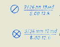 Place of capture of the prisoner. Here a soldier of the 2nd battalion of the 26th infantry regiment of the 19th mechanized division was captured at 5.00 on 12 August.
Place of confiscation of documents of the killed.
Weapons of mass destruction and protection against them
Nuclear strike planned by us. 015 - target number, 1/5 ordn - the first battery of the fifth cancer division. -40 - ammunition power 40 kilotons, B - air explosion. "H + 1.10 is the time of the explosion.
Safe removal line (projections towards the explosion).
The area of destruction from the explosion of the enemy. The inner ring is a zone of continuous destruction, then - a zone of solid blockages, weak destruction; the outer ring is the zone of neutron impact on the openly located personnel.
Fire area and direction of fire spread.
The place of a nuclear explosion produced by the enemy, indicating the type of explosion, power and time and the zone of radioactive contamination. The direction and size of the zones are scaled
Measurement point of the radiation level with indication of the level. time and date of infection.
Enemy nuclear mine with indication of charge power, depth of laying and time of detection.
Field of chemical landmines.
The area contaminated with toxic substances and the direction of displacement of the OM cloud.
Bioweapon contamination site.
Small arms and artillery
Light machine gun
Machine gun
Hand-held anti-tank grenade launcher
Automatic grenade launcher
Anti-aircraft missile system.
Anti-aircraft machine gun mount
Easel anti-tank grenade launcher
Wearable anti-tank missile systems (ATGM). Here 1- ATGM anti-tank machine gun platoon, 2- ATGM anti-tank platoon.
Flamethrowers. Here 1-jet light, 2-jet heavy.
Anti-tank gun. 1-general designation, 2- up to 85 mm, 3- up to 100mm, 4- more than 100mm.
A gun. 1- general designation, 2- up to 100mm, 3- up to 152mm, 4- more than 152mm.
Howitzer. 1- general designation, 2- up to 122mm., 3- up to 155mm., 4- more than 155mm.
Howitzer with a caliber over 155mm., Firing nuclear weapons.
Self-propelled howitzer. Here the caliber is up to 122 mm.
Rocket artillery combat vehicle. 1-general designation. 2- medium caliber.
Mortar. 1 - general designation, 2 - small caliber, 3 - medium caliber, 4 - large caliber.
Anti-aircraft gun. 1-general designation. 2-small caliber, 3-medium caliber.
Self-propelled anti-aircraft installation. 1- without radar, 2- with radar.
Fighting vehicle of the anti-aircraft missile system. The design of the sign depends on the type of the base vehicle, the icon inside depends on the type of rocket.
Anti-aircraft missile launcher. 1-short-range. 2 short range, 3 medium range. The sign in the circle is the Zen.PU battery.
The area of the firing positions of the artillery division. Here is the first division of the 12th artillery regiment. The signs of the batteries are off-scale, the area is large-scale.
The firing position of the battery is 100mm. guns.
Firing position of the mortar battery
Separate goal. 28 is the target number. The blue mark inside the circle is the location of the enemy's firearm.
Areas of concentration of fire. The numbers are the CO numbers. Large-scale signs.
Single fixed obstruction light with indication of its code name.
Deep fixed barrage on three lines with the indication of the code name Co and the numbers of the lines.
Single movable obstruction light with indication of its code name and line numbers.
Double movable barrage
Sequential concentration of fire, indicating the conventional names of the lines and target numbers (solid lines are the lines along which it is planned to fire simultaneously; with a double PSO, solid lines connect targets on two lines, with a triple line on three lines. Large-scale targets and sections of targets.
 Massive fire with indication of its code name and section numbers.
The firing rampart with indication of the conventional names of the lines, sections for divisions and their numbers, and the numbers of intermediate lines.
Boundary line of the firing sector
The boundary line of the additional shelling sector.
Concentrated fire from a motorized rifle company (SO-1 - sector number, 1,2,3 - platoon sector numbers.
The line of barrage of fire of a grenade launcher platoon with the marking of its number and sections of the lights of the squads.
Armored vehicles, cars and helicopters
Tank. 1- general designation, 2- battalion commander's tank, 3- amphibious tank, 4- flamethrower tank
Tank with a complex of anti-tank weapons.
Tank and BMP with a mine sweep
Tank with BTU
Tank with STU
Combat reconnaissance vehicle and combat reconnaissance patrol vehicle (BRDM)
Car and car with trailer
1-tank tractor, 2-track tractor, 3-car tractor
Motorbike
Ambulance car
Helicopter. 1- general designation, 2-combat, 3- transport.
Engineering equipment and structures
Tank bridgelayer
Tracked amphibious transporter
Self-propelled tracked ferry (ferry-bridge vehicle).
Engineering vehicles on a wheel base (Here is a heavy mechanized bridge TMM)
Engineering vehicles on a tracked base (Here BAT).
Pontoon-bridge park with a description of its type.
A trench of a motorized rifle unit with a closed gap
Trench with the passage of the message.
The gun is in the trench. The color of the trench mark by type of troops. (the same sign for all mobile fire weapons)
Open type observation structure (closed type with a black filled triangle.
Vehicle cover (vehicle icon by type)
Shelter indicating the degree of protection and capacity
Open slit
Closed gap
Escarp (counter-escarp) indicating the length.
Unobtrusive wire fence (spiral, net on low posts.
Anti-tank ditch with indication of the length.
Nadolby indicating the type, number of rows and length.
The mined blockage with an indication of the length.
Wire fence (number of lines - number of rows).
section of hedgehog barriers indicating the number of rows and length
Anti-tank minefield
Anti-personnel minefield (a mixed minefield is indicated by alternating open and filled circles)
Minefields established by means of remote mining.
1-unguided land mine, 2- radio-controlled land mine, 3-land mine, controlled by wires.
Passage through barriers with indication of number and width.
The bridge destroyed by the enemy
A section of the road destroyed by the enemy, indicating the extent of the destruction.
Amphibious crossing with an indication of the number and type of landing craft.
Crossing of tanks under water, indicating 3-depth, 180-width of the river, 40-width of the route, P-character of the bottom, 0.8- current speed.
Ferry crossing with indication of the number of ferries, their carrying capacity and the type of fleet
Ferry crossing of three GSP ferries and 3 ferries of 40 tons each and from PMM cars.
Rigid Supported Bridge. H-low-water 120m long, 4m wide. and with a carrying capacity of 60 tons.
Pontoon bridge 120 m long, with a carrying capacity of 60 tons from the PMP park
The ford is 0.8 m deep, the width of the river is 120 m, the bottom is solid, the current speed is 0.5 m per second.
Ice crossing number five for cargoes of 60 tons.
Subdivisions of technical support and rear, and their facilities
Collection point for damaged cars. P-regimental, 1- his number, bt- for armored vehicles
Repair and evacuation group on the armored personnel carrier. P-regimental, bt - for armored vehicles.
Regimental warehouse. G - fuel, 10tp - 10th tank regiment.
Regiment medical station.
Battalion medical station.
Medical post of the company
Shooter-orderly.
Ambulance transport post
Refueling point for fuel and lubricants of the battalion
Battalion ammunition point
Company ammunition station
Service point on the route. Г-ГСМ.
Combined arms units and subunits
- Motorized rifleman. regiment, battalion, company, platoon, squad - msv, msb, msr, msv, mso
- Tank regiment, battalion, company, platoon- tp, tb, tr, tv
- Machine gun and artillery battalion, company pulab, pular
- Airborne battalion, company, platoon- pdb, pdr, pdv
- Air assault battalion, company, platoon dshb, dshr, dshv
- Reconnaissance company, platoon, detachment- pp, rv, ro
- Machine gun company, platoon, squad pulr, pulv, pullo
- Anti-tank platoon ptv
- Grenade platoon, squad gv, go
- Anti-tank machine gun platoon ptpool
Artillery units and subunits
- Artillery regiment, battalion, battery- ap, adn, batr
- Self-propelled artillery battalion, battery sadn, sabatr
- Anti-tank guided missile battery Batr ATGM
- Mortar battery, platoon minbatr, minv
- Platoon control woo
Air defense units and subdivisions
- Anti-aircraft missile battery, platoon, squad - zrbatr, zrv, zro
- Anti-aircraft artillery battery, platoon, squad - zabatr, head, zo
- Anti-aircraft missile and artillery battery zrabotr
- Battery, platoon of self-propelled anti-aircraft guns Batr ZSU, vzv. ZSU
Special Forces Units
- Engineer-sapper company, platoon, detachment isr, isv, iso
- Engineering assault company, platoon, squad ishr, ishv, isho
- Airborne company pdesr
- Pontoon company, platoon Monday, Monday
- Platoon, branch of tracked amphibious transporters ex. GPT, dep. GPT
- Platoon, compartment of tracked self-propelled ferries - ex. GSP, dep. SHG
- Branch of bridgelayers dep. MTU
- Company, chemical protection platoon- rhz, vhz
- Platoon, department of radiation and chemical reconnaissance- vrhr, orhr
- Platoon, special treatment department vso, eso
- Flamethrower platoon, squad ov, oo
- Company, platoon, post office- pc, sun, os
- Commandant company, platoon cr, sq.
Subdivisions of technical support and logistics
- Separate battalion, logistics company obmo, rmo
- Automobile company, platoon, squad avtr, avtv, auto
- Repair company remr
- Maintenance platoon, department host, host
- Supply platoon, supply platoon wob, sun
- Maintenance department oto
Control points
- Command post- KP
- Rear command post TPU
- Command and observation post- KNP
- Reserve command post - ZKP
- Observation post- NP
- Air observation post PVN
- Artillery observation post ANP
- Technical supervision point PTN
- Engineering Observation Post INP
General Purpose Terminology
- Vanguard (rearguard) - Av (Ar)
- Bacteriological (biological) weapons BO
- Bacteriological (biological) infection BZ
- Battalion refueling point - BZP
- Fighting machine- BM
- Infantry fighting vehicle- BMP
- Combat reconnaissance vehicle BRM
- Combat reconnaissance patrol vehicle- BRDM
- Side marching outpost- BPZ
- Armored personnel carrier Armored personnel carrier
- Combat kit bq.
- Explosives- BB
- Height- h.
- Head marching outpost- GPP
- Head watch- DG
- Diesel fuel- DT
- Long-term firing structure (long-term fortification) - DOS (DFS)
- Incendiary weapons (incendiary means) - ZZhO (ZZhS)
- Refueling request
- Protection against weapons of mass destruction ZOMP
- Zone of radioactive, chemical, bacteriological (biological) contamination - ZRZ, 3X3, ZBZ
- Self-propelled anti-aircraft installation ZSU
- Starting line (starting point) - ref. p-f, (out.p.)
- Kiloton- kt
- Command vehicle KShM
- Set- set
- Commander of the 1st motorized rifle, 2nd tank battalion- kmsb-1, ktb-2
- Commander of the 1st motorized rifle, 2nd tank company kmsr-1, ktr-2
- Commander of the 1st motorized rifle, 2nd tank platoon- Kmsv-1, ktv-2
- Mine-explosive obstacle- Cost center
- Regiment medical station- WFP
- Battalion medical station BCH
- Company medical post MNR
- Emergency ration- NZ
- Irreducible stock NSZ
- Firing position- OP
- Outskirts env.
- Poisonous substances (persistent toxic substances, unstable toxic substances) - 0V (COB, NOV)
- Mark- mark
- Separate- dep.
- Forward detachment ON
- Movable detachment of obstacles POZ
- Field refueling point - PPP
- Consistent concentration of fire PSO
- Enemy- avenue
- Air defense (anti-tank defense) - Air defense (PTO)
- Anti-personnel minefield PPMP
- Anti-tank minefield PTMP
- Anti-tank reserve PTrez.
- Radioactive contamination RZ
- Radioactive substances PB
- Radiation and chemical reconnaissance RHR
- Reconnaissance detachment- RO
- Dividing line clearing lines
- Radio network (radio direction) - r / s (r / n)
- District- NS
- Repair and evacuation group (repair group) - REG (Rem. G)
- Regulation line (regulation point) - pg per. (p. per.)
- Collection point for damaged machines SPPM
- Guard detachment (outpost, outpost) - Art.O (Art.Z, Art.P)
- North, South, East, West- north., south., east., west.
- Northwest, northeast, west, southeast, southwest- north-west, north-east, south-east, south-west.
- Focused Fire- CO
- Daily cottage s / d
- Tactical airborne assault Tact. VD
- Tank bridgelayer MTU
- Rear marching outpost - TPZ
- Communication node mustache
- Fortified area- SD
- Chemical observation post KhNP
- Chemical contamination HZ
- Chemical weapon- NS
- Chemical land mine HF
- Nuclear weapon- YAO
- Nuclear mine
- NM Nuclear mine fence- YaMZ
Selected local subjects
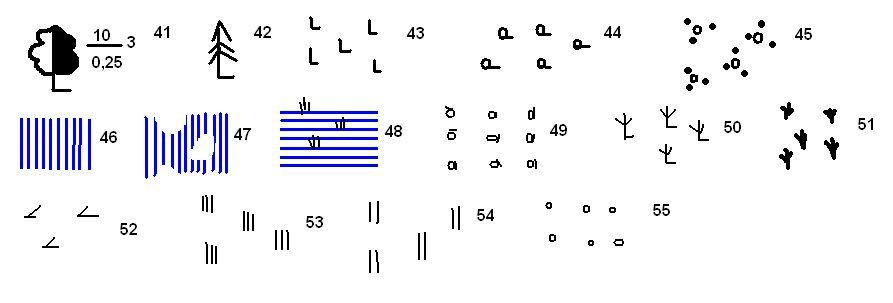
Plants, factories and mills with pipes, expressed (1) or not expressed (2) on the scale of the map |
||
Tower-type capital structures |
Light towers |
Power plants |
Transformer booths |
Points of the state geodetic network |
Aerodromes and hydro aerodromes |
Water mills and sawmills |
Windmills |
Wind turbines |
 Plants, factories and mills without pipes: 1) expressed in the scale of the map; 2) not expressed in the scale of the map. |
Radio stations and television centers |
Radio masts and television masts |
Fuel warehouses and gas tanks |
Stand-alone trees with landmarks: 1) conifers; 2) deciduous |
 Separate groves with meaningful landmarks |
Narrow forest strips and protective forest stands |
Narrow strips of shrubs and hedges |
Separate bushes |
Communication lines |
 Mounds, height in meters |
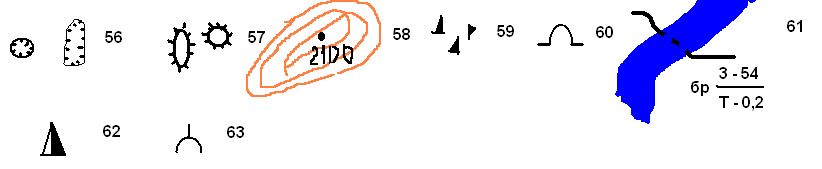
Outlier rocks |
Power lines on metal or reinforced concrete supports |
 Pits, depth in meters |
Clusters of stones |
Power lines on wooden poles |
Meteorological stations |
Separate stones, height in meters |
Onshore oil pipelines and pumping stations |
 Open pit mining sites |
Peat mining |
Underground oil pipelines |
Churches |
Monuments, monuments, mass graves |
Stone, brick walls |
Dams and shafts |
Foresters' houses |
Roads
 Three-track railways, semaphores and traffic lights, turntables |
Highway: 5-width of the covered part, 8-width of the entire road from ditch to ditch in meters, B-coating material |
 Double track railways and stations |
 Improved dirt roads (8-carriageway width in meters) |
 Single track railways, sidings, platforms and stopping points |
Dirt roads |
 Electrified railways: 1) three-track; 2) double-track; 3) single-track |
Field and forest roads |
Narrow gauge railways and stations on them |
Hiking trails |
 Freeways, embankments |
 Fascinated sections of roads, gats and rowing |
 Improved highways, notches |
 Crossings: 1) under the railway; 2) over the railway; 3) on the same level |
Hydrography
 Small rivers and streams |
 The banks are steep: 1) without a beach; 2) with a beach that does not end on the scale of the map |
 Canals and ditches |
 Lakes: 1) fresh; 2) salted; 3) bitter-salty |
 Wooden bridges Metal bridges Stone and reinforced concrete bridges |
 Characteristics of bridges: K-building material (K-stone, M-metal, RC-reinforced concrete, D-wooden); 8-height above water level (on navigable rivers); 370-length of the bridge, 10-width of the carriageway in meters; 60-tonne lifting capacity |
 Water edge marks Arrows showing the direction of the flow of rivers (0.2-flow rate in m / sec.) |
 Characteristics of rivers and canals: 170-width, 1.7-depth in meters, P-character of the bottom soil Pier Brody: 1.2-depth, 180-length in meters, T-nature of the soil, 0.5-current speed in m / s. |
 Dams: K-material of the structure, 250-length, 8-width of the dam at the top in meters; in the numerator is the mark of the upper water level, in the denominator is the lower |
 Gateways Ferries: 195-width of the river, 4x3-dimensions of the ferry in meters, 8-carrying capacity in meters |
Ground water pipelines |
Wells |
Underground water pipes |
Sources (keys, springs) |
The system of basic conventional symbols used in graphic documents of peace and wartime tactical level Part 4 "Motorized rifle battalion" -
The procedure for the formation of a combat graphic document. Fire card of a motorized rifle squad when planning offensive actions. Situation conditions: COMBAT ACTIVITIES. Type of combat operations - OFFENSIVE -
SYMBOLS FOR TOPOGRAPHIC PLANS -
In general, when hunting, you also need a certain tactic similar to the one that will be described in this article. And you don't need to buy firearms for hunting, just take a pistol-type ballets and start hunting. In general, it is more convenient and more enjoyable. Also, this kind of crossbow can be used for ordinary sports purposes - target shooting.
on a topographic map.
You have come across a map that is little known from the secret archives of a district or region. And there, farms that have disappeared long ago, and villages, and stanitsas and many more incomprehensible signs, lines and dots. What do the icons on a topographic map mean? How to understand and determine where is the active settlement, where is the disappeared, where is the cemetery, and where is the living spring with crystal clear drinking water, which can be useful to you in hot summer weather during the hunt. Someone will say that it was necessary to study geography, and this is correct, but you will not remember everything.And for us, treasure hunters and amateur archaeologists, it is important to be able to correctly read a topographic map for correct and quick orientation in the area. Okay, when you search for antiques in a familiar area. And if this is a foreign area or region? Old-timers of treasure hunting advise to conduct a cop together, in a company. So you may be able to protect yourself from the attacks of local residents and government officials. You will have fun in the company of like-minded people, and if something unexpected happens, they will definitely help you. But if not one of you does not know the decoding of the designation of the icons on a topographic map, you are worth a penny. Running from side to side, frantically looking around at random for excavation sites is stupid, defiant, excessive fuss attracts negative attention.
And so, let's proceed to a detailed study of the designations on your secret treasure map.
1. Multiple buildings.
2. Destroyed buildings.
3. Single building.
4. The destroyed building.
5. Working mines.
6. Closed mines.
7. Industrial enterprise (plant, factory).
8. Factory pipe.
9. Power plant.
10. Warehouse for fuels and lubricants.
11. The tower is either stone or metal.
12. Tower of light construction (from the corners).
13. Television and radio towers.
14. Distribution transformer.
15. Center for television or radio broadcasting.
16. Aircraft runway (airfield).
17. Housing of the forester.
18. Geodetic point.
19. Railroad.
20. Stone or brick fence (fence).
21. Spring.
22. Well of water (crane).
23. Wind well.
24. An ordinary well, log house.
25. Muslim cemetery.
26. The main locations of the sites of chums and yurts.
27. Electric wires on wooden poles.
28. Electric wires on concrete poles.
29. Motors powered by wind (power plants).
30. Windmills.
31. Large-scale peat extraction.
32. Water mill.
33. Gas station.
34. Meteorological point.
35. Chapel.
36. Church (temple, cathedral).
37. Big cemetery.
38. Small cemetery.
39. Monuments, obelisks, memorials and monuments.
40. Beekeeping apiary.
41. Forest. The numbers in the numerators - the height, in the denominators - the girth of the trunk, the number next to it - the distance between the trees. Ahead of the fractions, they can write which forest: birch, maple, oak, or mixed.
42. Coniferous forest.
43. Forest cut down.
44. Rare forest.
45. Sprouts of bushes.
46. The salt marshes are not passable.
47. Passable salt marshes.
48. Impenetrable swamps with vegetation. If there are three lines (as in the picture) - moss. If two dashes are grass. Reeds or reeds are depicted by a bush.
49. Fruit garden.
50. Dry wood or burnt.
51. Reed or reed.
52. Forest felled by a storm (hurricane, tornado).
53. High herbage.
54. Meadow vegetation, less than one meter in height.
55. Young trees.
56. Ravines and pits.
57. Mounds.
58. The height is absolute.
59. Stones.
60. Cave.
61. Indication of a ford on the river. The first digit in the denominator is the depth, the second is the length. In the numerator, the first is the type of soil (T - solid), the second is the speed of the river.
62. Waste heaps.
63. Calcining of lime.

Geography. Modern illustrated encyclopedia. - M .: Rosman. Edited by prof. A.P. Gorkina. 2006 .
See what "conventional signs" are in other dictionaries:
Symbolic, line and background designations of terrain objects, combat and meteorological conditions, used on topographic and other geographical maps, as well as on graphic documents. Depending on the purpose, they distinguish ... ... Marine dictionary
Symbols- Symbols ... Geographic Atlas
Graphic, alphabetic and digital designations of objects and terrain elements, operational tactical and meteorological conditions, used on topographic and other geographical maps, as well as on graphic documents. Depending on the… … Emergency Dictionary
Symbols- graphic symbols and standard abbreviations of explanatory inscriptions to them, used in military operational documents, on diagrams, maps, report cards, etc. to indicate the position of troops, rear units (subunits) ... ... A short dictionary of operational-tactical and general military terms
conventional signs- sutartiniai ženklai statusas T sritis Gynyba apibrėžtis Vietovės objektų, kovinės ir meteorologinės situacijos žymėjimo žemėlapiuose ir kt. koviniuose grafiniuose dokumentuose ženklai. Pagal paskirtį jie būna taktiniai, topografiniai ir…… Artilerijos terminų žodynas
conventional signs- sutartiniai ženklai statusas T sritis ekologija ir aplinkotyra apibrėžtis Grafiniai simboliai, kuriais žemėlapiuose reiškiamas jų turinys. Simboliais vaizduojami fiziniai Žemės paviršiaus objektai (jų padėtis, kiekybiniai ir kokybiniai ... ... Ekologijos terminų aiškinamasis žodynas
Symbols- signs used in drawing up plans and diagrams of the scene of the incident and other places of investigation. They are a set of standard topographic signs and designations of objects found in the investigation ... ... Forensic encyclopedia
Symbols- symbolic line and background designations of terrain objects, combat and meteorological conditions, used on geographical maps and graphic documents. Topographic, tactical, and meteorological conditions are distinguished. They can… … Dictionary of military terms
SYMBOLS- GENERAL INFORMATION ABOUT THE MATERIALS Name of the mainland Area in thousand sq. M. km Coordinates of extreme points Highest altitude above sea level Lowest altitude from sea level Eurasia 54 870 s. m. Chelyuskin 77º43 ′ N 104º18 ′ E south m. ... ... Geographic Atlas
Cartographic conventional signs are a system of symbolic graphic designations used to depict various objects and phenomena on maps, their qualitative and quantitative characteristics. Symbols used on the map ... ... Wikipedia
Books
- , Symbols for topographic plans. Scales 1: 5000, 1: 2000, 1: 1000 and 1: 500 Reproduced in the original author's spelling of the 1973 edition (publishing house `Nedra`). ... Category: Agricultural machinery Publisher: YoYo Media, Manufacturer: YOYO Media,
- Symbols for topographic plans, Main Directorate of Geodesy and Cartography under Sowa, Symbols of geodetic points, buildings, buildings and their parts, railways and structures with them, highways and dirt roads, hydrography, bridges, overpasses and ... Category: Agricultural machinery Publisher: YoYo Media, Manufacturer:
Declassified topographic maps of the General Staff of the USSR are freely walking around the Internet. We all love to download them, view, and often print on sheets of paper for further use for their intended purpose - i.e. go hiking with them.
The topographic maps of the General Staff are the most accurate and the best. Any other purchased cards printed in modern times will not carry as much accuracy and specificity. Symbols and designations on topographic maps of the General Staff are much more complex than any other designations for maps purchased in the store. We all remember them from our geography lessons at school.
As an experienced user of such maps, at the beginning of this article I would like to describe the most important, in my opinion, designations. If the rest are more or less clear, since they are almost all identical with other types of maps (not the General Staff), then these are something new and still incomprehensible. Actually, I will start with the symbols of rivers, fords, forests and roads.
Rivers and water resources
| River speed and direction (0.6 m / s) | |
|
Characteristics of rivers and canals: 30 - Width (m), 0,8 - Depth (m), TO- Type of soil ( TO - stony, NS - sand, T - solid, V - viscous) |
 |
| Water edge elevation, shore height above sea level (393m) |  |
| Brody: 0,3 - depth, 10 - length, TO- rocky ground, 1,0 - speed (m / s) |  |
| Swamp passable |  |
| Impenetrable swamp |  |
| Characteristics of bridges: D- building material ( D - wood, TO - stone, ZhB - reinforced concrete), 43 - the length of the bridge, 4 - width of the carriageway (m), 10 - carrying capacity in tons |  |
| Forest clearing and width in meters (2m) |  |
| Field and forest roads |  |
| A winter road, an operating road only in the winter season, in the cold season. Can walk through swamps. |  |
| Dirt road, 6 - width of the carriageway in meters |  |
| Gat - a road with a wooden surface, a flooring of logs, 3 - width of the carriageway |  |
| Gat |  |
| Railway bed |  |
| Gas pipeline |  |
| Power lines (TL) |  |
| Dismantled railway |  |
| Single track railway, narrow gauge railway. Also railway bridge |  |
| Highway: 6 - width of the coated part, 8 - the width of the entire road from ditch to ditch in meters; SCH- coating material ( B - cobblestone, G - gravel, TO - chipped stone, Shl - slag, SCH - crushed stone) |  |
Relief
| Steep river banks, rocky outcrops, parma |  |
| Contours of the relief with the designation of the relative height (260 m) |  |
| Mountainous area without vegetation, covered with stones-curums and outlier rocks |  |
| Mountainous terrain with vegetation and rare trees, the border of the forest is visible |  |
| Outlier rocks with a height in meters |  |
| Glaciers |  |
| Rocks and rocky cliffs |  |
| Height mark (479.2 m) |  |
| Steppe region. Near the border of the forest |  |
| Sands, deserts |  |
Photos of some geographic objects


Main winter road, laid through the taiga forest. In summer, there are thickets (Yakutia)

Forest dirt road (Ivdel district, North Ural)

Gat - a road with a wooden surface (Lobnensky forest park, Moscow region)

Rock outcrop, Parma (Stone "Giant", Wed Ural)

Outlier rocks (Starik-stone rock, Wed Ural)
It should be understood that all available topographic maps of the USSR General Staff are outdated long ago. The information contained on them can date back to 70-80 years of the last century. If you are interested in the details of the passage along certain paths, roads, the presence of settlements and geographical objects, then you should check the reliability of the information from other sources in advance. There may be no trails and roads at all. Small settlements can be abandoned and represent wastelands, often already overgrown with young growth.
But, in any case, the maps of the General Staff still carry more accurate information, and using them you can more efficiently calculate your route and distance. In this article, I did not bother to fill your heads with unnecessary symbols and conventional signs of topographic maps. I have posted only the most important and significant ones for the mountain taiga and steppe regions. Anyone interested in the details can see.
The maps of the USSR General Staff were made using the Soviet system of plotting and the nomenclature of topographic maps. This system is still used in the Russian Federation and in some of the former Soviet republics. There are newer maps, the state of the terrain on which is approximately 60-80-ies of the last century, and older maps, the so-called General Staff of the Red Army, made by geodetic reconnaissance before the war. "Maps are drawn in the Gauss-Kruger conformal transverse-cylindrical projection, calculated from the parameters of the Krasovsky ellipsoid for a six-degree zone," - and if you do not understand, then it does not matter! The main thing is to remember (or write down, save this article) the moments that I gave above. Knowing them, you can skillfully use maps and plan your route without using gps.
The main elements of the content of the map. Large-scale, off-scale and explanatory symbols. Card design. General rules for reading topographic maps
Basic elements of map content
Symbols are graphic designations that show the position of an object on the ground and convey its qualitative and quantitative characteristics. In the Russian Federation and the CIS countries, 465 conventional symbols are used (in the USA - 243, in France - 288, in the FRG - 231).
Groups of homogeneous local objects are depicted on maps using the main (basic) conventional sign. The qualitative and quantitative characteristics of objects of one group are determined by increasing the complexity of the basic conventional sign.
The larger the scale of the map, the more objects and in greater detail are shown on it when depicting a given territory. With a decrease in the scale of the map, the information capacity of the image of various objects on it decreases.
On topographic maps at a scale of 1: 25000 - 1: 100000, whenever possible, all topographic objects and their characteristic features that are important for the troops are shown. On maps of scales 1: 200000 and 1: 500000, only the most significant of them are displayed, and with a significant generalization of their planned outlines and other indicators.
Symbols of local objects are divided into three main groups:
Large-scale;
Off-scale;
Explanatory.
Scale (or outline) conventional symbols denote objects that are expressed in the scale of the map, that is, those whose dimensions (length, width, area) can be measured on the map.
Each such sign consists of a contour, i.e. the plan outline of the depicted object and the explanatory designation that fills it in the form of a background color, colored shading or a grid of icons (memory signs) of the same pattern, indicating the type and variety of the object. The contours of objects are shown on maps with a dotted line if they do not coincide with other terrain lines (ditches, coastlines, roads, etc.), which are indicated by their conventional symbols.
Off-scale (point) conventional signs depict small-sized objects (wells, individual houses, towers, monuments, etc.) that are not expressed in the scale of the map, the figured drawing of such a sign includes the main point showing the exact position of the object on the ground, and indicates what kind of object it is.
Out-of-scale conventional symbols can be divided into 4 groups depending on the position of the main point:
Signs with a center of symmetry (circle, square, rectangle, asterisk, etc.); the main point coincides with the center of symmetry;
Signs with a wide base, the main point is in the middle of the base;
Signs with a base in the form of a right angle; the main point is at the top of the corner;
Signs representing a combination of several shapes; the main point is the symmetry of the lower figure in the center.
Geometric center of the figure
Rice. 1.1 - points of the geodetic network; 2 - points of the survey network, fixed on the ground by centers; 3 - astronomical points; 4 - churches; 5 - factories, factories and mills without pipes; 6 - power plants; 7 - water mills and sawmills; 8 - fuel depots and gas tanks; 9 - operating mines and adits; 10 - oil and gas wells without rigs.
The middle of the base of the sign
Rice. 2 . 1 - factory and factory pipes; 2 - waste heaps; 3 - telegraph and radiotelegraph offices and branches, telephone exchanges; 4 - meteorological stations; 5 - semaphores and traffic lights; 6 - monuments, monuments, mass graves, tours and stone pillars more than 1 m high; 7 - Buddhist monasteries; 8 - separately lying stones.
Vertex of a right angle at the base of the sign
Rice. 3. 1 - wind turbines; 2 - gas stations and filling stations4 3 - windmills; 4 - permanent signs of river signaling; 5 - freestanding deciduous trees; 6 - freestanding conifers
The geometric center of the lower figure
Rice. 4.1 - factories, factories and mills with pipes; 2 - transformer booths; 3 - radio stations and television centers; 4 - oil and gas rigs; 5 - tower-type structures; 6 - chapels; 7 - mosques; 8 - radio masts and television masts; 9 - furnaces for burning lime and charcoal; 10 - mazars, sub-organs.
These main points must be used when accurately measuring the distances between objects on the map and when determining the coordinates of objects. Out-of-scale conventional signs include such signs of roads, streams and other linear objects, in which only the length is expressed in scale, but the width cannot be measured on the map. The exact position of such objects on the ground corresponds to the longitudinal axis (middle) of the sign on the map.
Explanatory symbols are used for additional qualitative and quantitative characteristics of the depicted objects and display of their varieties (for example, the symbol of a tree inside a forest).
Card design
Out-of-the-box registration of topographic maps. On each sheet of the topographic map, on the outside of the frame, various information necessary for working with cardboard is placed.
The number and year of issue of the card are given under the nomenclature.
Under the lower (southern) side of the frame on the left, data on the magnetic declination, the approach of the meridians and the direction correction are given, and the drawing shows the relationship of these angular values; the linear and numerical scales of the map are placed in the middle, the magnitude of the scale and the height of the relief section are indicated; to the right of the scale there is a scale of laying, intended for determining the steepness of the slopes; on the right it is indicated when and by what method the map was created. The data on the time of creation of the map allows us to judge the conformity of the map of the area at the moment (period).
Between the inner and outer lines of the frame of the map sheet, the digitization of the vertical and horizontal lines of the coordinate (kilometer) grid and the labels of the geographical coordinates (latitude and longitude) of the corners of the frame are given.
The sides of the frame are divided into minute divisions (in latitude and longitude), and each minute division by dots is divided into six parts, ten seconds each.
In addition, at the exits of railways and highways, the name of the nearest city, village or station to which this road leads is given, indicating the distance in kilometers from the frame to this settlement (station).
Inside the frames, the own names of settlements are also signed, which are only partially depicted on this sheet, and most of them are located on the adjacent sheet.
General rules for reading topographic maps
Reading a map means correctly and fully perceiving the symbolism of its conventional signs, quickly and accurately recognizing from them not only the type and varieties of objects depicted, but also their characteristic properties.
Studying the terrain on a map (reading a map) includes determining its general nature, quantitative and qualitative characteristics of individual elements (local objects and landforms), as well as determining the degree of influence of a given terrain on the organization and conduct of a battle.
Studying the terrain on the map, it should be remembered that since its creation, changes may have occurred on the terrain that are not reflected on the map, that is, the content of the map will in some way not correspond to the actual state of the terrain at the moment. Therefore, the study of the area on the map is recommended to start with familiarization with the map itself.
Familiarization with the map. When familiarizing with the map, according to the information placed in the out-of-frame design, the scale, the height of the relief section and the time of creating the map are determined. Data on the scale and height of the relief section will allow you to establish the degree of detail of the image on this map of local objects, forms and relief details. Knowing the magnitude of the scale, you can quickly determine the size of local objects or their distance from each other.
Information about the time of creation of the map will make it possible to preliminarily determine the correspondence of the content of the map to the actual state of the area.
Then read and, if possible, memorize the values of the declination of the magnetic needle, direction corrections. Knowing the direction correction from memory, you can quickly translate directional angles into magnetic azimuths or orient the map on the ground along the line of the kilometer grid.
General rules and sequence for studying the area on the map. The sequence and degree of detail in the study of the terrain is determined by the specific conditions of the combat situation, the nature of the combat mission of the subunit, as well as the seasonal conditions and tactical and technical data of the combat equipment used in the performance of the assigned combat mission. When organizing defense in a city, it is important to determine the nature of its planning and development, to identify durable buildings with basements and underground structures. In the event that the route of the movement of the unit passes through the city, there is no need to study the features of the city in such detail. When organizing an offensive in the mountains, the main objects of study are passes, mountain passes, gorges and gorges with adjacent heights, the shape of slopes and their influence on the organization of the fire system.
The study of the terrain, as a rule, begins with a determination of its general character, and then a detailed study of individual local objects, forms and details of the relief, their influence on the conditions of observation, camouflage, passability, protective properties, conditions of fire and orientation.
Determination of the general nature of the area is aimed at identifying the most important features of the relief and local items that have a significant impact on the implementation of the task. When determining the general nature of the terrain on the basis of familiarization with the relief, settlements, roads, hydrographic network and vegetation cover, the variety of this area, the degree of its ruggedness and closure, is identified, which makes it possible to preliminarily determine its tactical and protective properties.
The general nature of the terrain is determined by a quick overview of the map of the entire study area.
At first glance at the map, one can say about the presence of settlements and individual tracts of forest, cliffs and gullies, lakes, rivers and streams indicating the roughness of the terrain and a limited view, which inevitably complicates the movement of military and transport equipment off the roads, creates difficulties in organizing observation ... At the same time, the rugged nature of the relief creates good conditions for sheltering and protecting subunits from the effects of weapons of mass destruction of the enemy, and forest tracts can be used to camouflage subunit personnel, military equipment, etc.
So, as a result of determining the general nature of the terrain, a conclusion is made about the availability of the area and its individual directions for the actions of subunits in vehicles, and also outline the lines and objects that should be studied in more detail, taking into account the nature of the combat mission to be performed in this area of the terrain.
A detailed study of the terrain is aimed at determining the qualitative characteristics of local objects, forms and details of the relief within the boundaries of the unit's actions or along the upcoming route of movement. On the basis of obtaining such data from the map and taking into account the relationship of topographic elements of the terrain (local objects and relief), an assessment of the conditions of passability, camouflage and observation, orientation, firing is made, and the protective properties of the terrain are determined.
Determination of the qualitative and quantitative characteristics of local objects is made on the map with relatively high accuracy and great detail.
When studying on a map of settlements, the number of settlements, their type and dispersion is determined, the degree of habitation of a particular site (district) of the area is determined. The main indicators of the tactical and protective properties of settlements are their area and configuration, the nature of planning and development, the presence of underground structures, the nature of the terrain on the outskirts of the settlement.
Reading the map, using the conventional signs of settlements, they establish the presence, type and location of them in a given area of the terrain, determine the nature of the outskirts and layout, density for
construction sites and fire resistance of buildings, the location of streets, main thoroughfares, the presence of industrial facilities, outstanding buildings and landmarks.
When studying the road network map, the degree of development of the road network and the quality of roads are specified, the conditions for the passability of a given area and the possibility of effective use of vehicles are determined.
A more detailed study of the roads establishes: the presence and characteristics of bridges, embankments, excavations and other structures; the presence of difficult sections, steep descents and ascents; the possibility of leaving the roads and driving next to them.
When studying dirt roads, special attention is paid to identifying the carrying capacity of bridges and ferry crossings, since on such roads they are often not designed for the passage of heavy wheeled and tracked vehicles.
Studying hydrography, the presence of water bodies is determined on the map, the degree of indentedness of the terrain is specified. The presence of water bodies creates good conditions for water supply and transportation by waterways.
Water surfaces are depicted on maps in blue or light blue, so they stand out clearly from the conventional symbols of other local objects. When studying rivers, canals, streams, lakes and other water barriers on a map, the width, depth, current speed, the nature of the bottom, banks and adjacent terrain are determined; the presence and characteristics of bridges, dams, locks, ferry crossings, fords and sections convenient for crossing are established.
When studying the soil and vegetation cover, the presence and characteristics of forest and shrub areas, swamps, salt marshes, sands, stony placers and those elements of soil and vegetation cover that can have a significant impact on the conditions of passability, camouflage, observation and the possibility of shelter are established on the map.
The characteristics of the forest area studied on the map allow us to conclude that it can be used for a secret and dispersed location of units, as well as the forest's passability along roads and clearings. Good landmarks in the forest for determining your location and orientation in motion are the forester's house and clearings.
The characteristics of the swamps are determined by the outlines of conventional symbols. However, when determining the passability of swamps on the map, one should take into account the time of year and the state of the weather. During the period of rains and mudslides, swamps, shown on the map with a conventional sign as passable, in reality may turn out to be difficult to pass. In winter, during severe frosts, rugged swamps can become easily passable.
The study of the relief on the map begins with determining the general nature of the irregularities of that part of the terrain on which the combat mission is to be performed. At the same time, the presence, location and interconnection of the most typical typical forms and relief details for a given site are established, their influence on the conditions of cross-country ability, observation, firing, camouflage, orientation and organization of protection against weapons of mass destruction is determined in general terms. The general nature of the relief can be quickly determined by the density and outline of contour lines, elevation marks and conventional signs of relief details.
A detailed study of the terrain on the map is associated with solving problems of determining the heights and mutual excess of points, the type and direction of the steepness of the slopes, characteristics (depth, width and length) of hollows, ravines, gullies and other relief details.
Naturally, the need for solving specific tasks will depend on the nature of the assigned combat mission. For example, the definition of invisibility fields will be required when organizing and conducting reconnaissance by observation; determining the steepness, height and length of the slopes will be required when determining the terrain passability conditions and choosing a route of movement, etc.